(Note: this was written by me in October 2023)
ABSTRACT
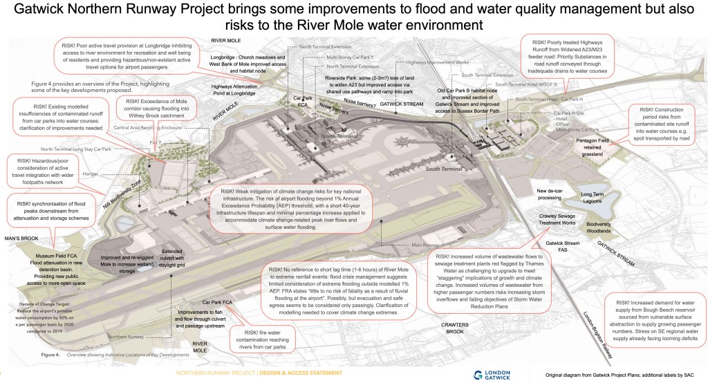
Overall, the Gatwick Northern Runway Project has schemes that could improve on existing flood risk mitigation and water quality management. Several schemes seek to improve the local river environment and access to it. Examples of welcome improvements include the Museum Field FCA, the de-culverting of a section of the Gatwick Stream, new arrangements for de-icer processing, improvements to the runway culvert and flood plain restoration downstream.
However, a number of questions are raised with regard to elements of the plans which appear to be less robust and at least require more details. Specifically, the concerns highlight questions regarding the resilience to climate change risks, the treatment of hazardous road runoff into water courses, capacity to sustainably meet growing water demands, and the competence of struggling local sewage treatment works to manage increased volumes of wastewater. The primary objective of mitigations should be to ensure the river is able not only to survive the Project but to thrive and achieve “Good” ecological status in the future. There are also concerns that the plans seem to overlook the opportunity to enhance residents’ access and enjoyment of local habitat through improved active travel options along the river corridors and to address the pressing need for better airport access for pedestrians and cyclists.
Posted 21 Oct 2023; Slight amendments 22 Oct 2023.
Here is my review of the proposed plans for the Northern Runway Project at Gatwick Airport regarding impacts on the River Mole. It looks at how the development might impact water environments in the Upper Mole. As usual I try to be balanced so have sought to identify positive aspects as well as points that need more clarification or seem less robust.
In this post I cover the following topics:
- Key Elements of The Northern Runway Project
- Characteristics of the Existing Water Environment: the River Mole and Gatwick Stream
- Existing and Future Flood Risk at the Airport
- Northern Runway Project: Plans for Flood Risk Mitigation and Water Quality Management:
- 1.Fluvial Flood Risk and Water Quality Mitigation Measures
- Realignment and naturalisation of the River Mole downstream of the northern runway
- Museum Field Flood Compensation Area
- Clarifying de-synchronisation of flood peaks
- Improved public access to wider countryside
- 2.Surface Water Flood Mitigation and Water Quality Treatment Measures
- Fire Risk in Car Parks
- 3.Highways: Flood and Water Quality Mitigation Measures
- 1.Fluvial Flood Risk and Water Quality Mitigation Measures
- Increasing flows of Wastewater and risk of impact on the River Mole
- Airport Water Supply
- Construction Period Risks
- Summary points and questions
I’m only considering how the Project potentially impacts the water environment and not any wider discussion of the pros and cons of aviation or flying such as carbon emissions.
The report is long so there’s a summary at the end if you want to skip to that.
The airport is located over the River Mole floodplain which makes it a potential source of pollution and flooding. However, the airport recognises its responsibility to manage runoff and water quality and they have a tight regime of airside water quality management and runoff attenuation. Gatwick has grown substantially in recent years, increasing annual passenger numbers from 31 million in 2010 to 46.5 million in 2019 and throughout that time there have been investments in flood control and water quality management. If you want to find more about how the airport manages flood control and water quality please read my post here, several years old now but still a relevant summary:
Over the years, there has been a welcome willingness from the airport to share how they do things in respect of water quality management and flood control. The focus of this post is to see what the Northern Runway plans available so far suggest about how flood risk, water quality and public access to rivers might change and to ask questions about the plans to ensure river environments are not damaged and, indeed, could be improved according to National Planning guidance. As usual I’ve trawled through a lot of planning documents (references below). This is my best take on what’s available and hope it forms a balanced enquiry. Some aspects of the Project are potentially beneficial to the water environment, for example by improving on existing schemes. Other aspects of the Project appear to risk deterioration from what appears in the plans available so far. Where there appears to be a risk to the water environment, more details and clarification of plans are requested.
Discussions are welcome in the comments below and let me know if you spot something awry or which needs clarifying. I hope you find it interesting.
Key Elements of The Northern Runway Project
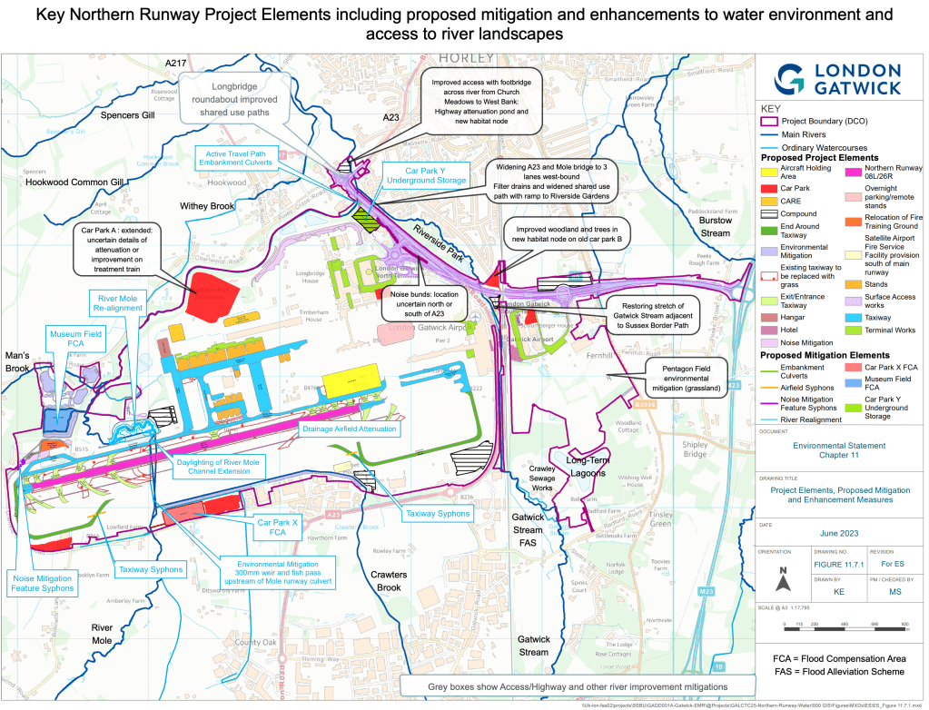
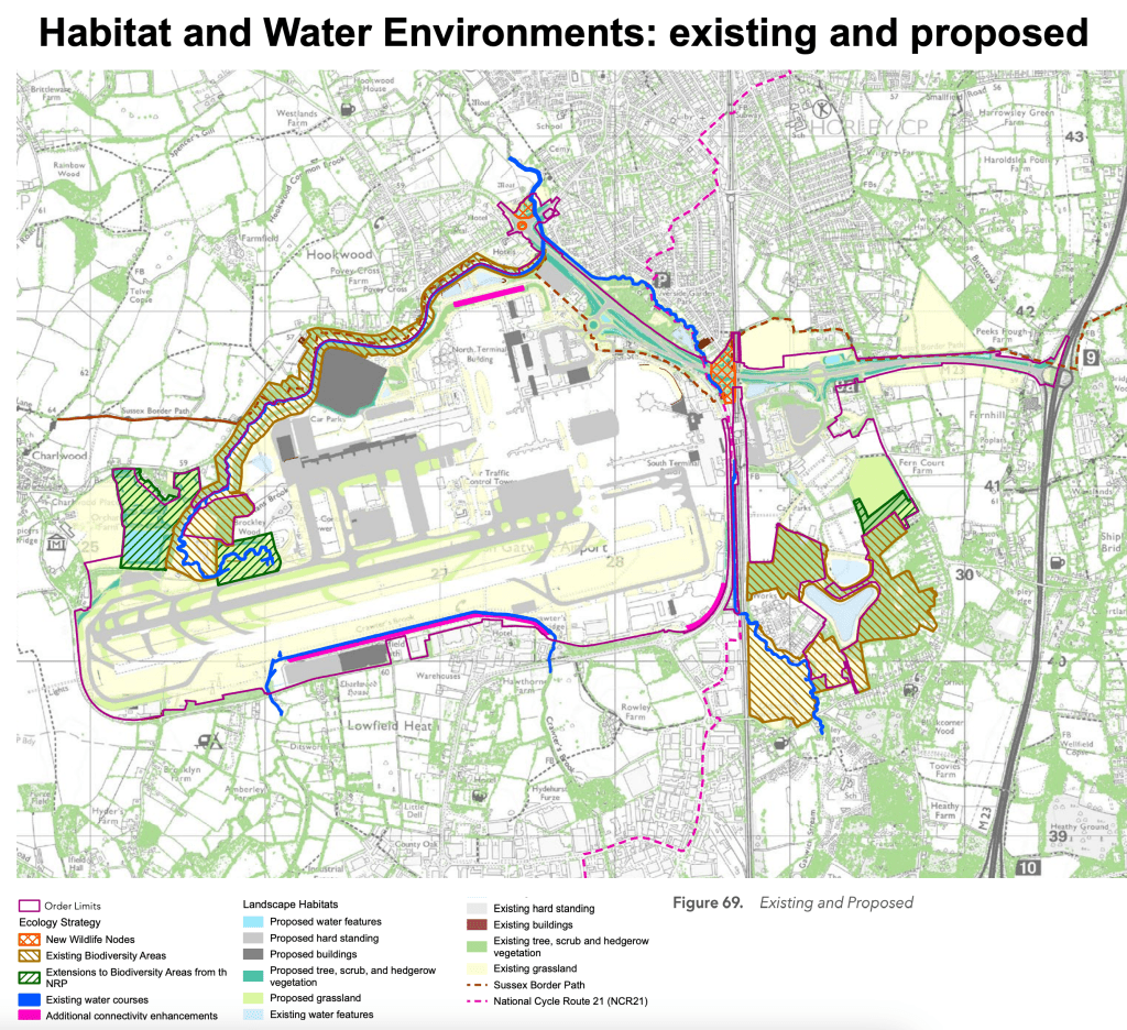
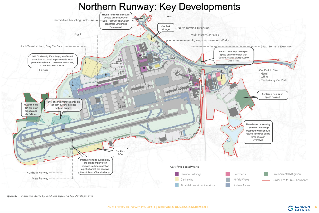
The Project proposes to bring into service the northern runway which is coloured pink on the map below. This will mean repositioning its centreline to the north by ~12 metres along with an adjacent taxiway. The reconfiguring of the runway will involve numerous additional knock-on developments around the airport including an increased cover of impermeable surfaces, more car parking, widening of the A23 airport feeder road, adjustments to road junctions and bridges at Longbridge and the North and South Terminal roundabouts, changes to active travel provision and public access around the airport, increased demand for water supply and flows of wastewater to local treatment plants and lengthening of the runway culvert with some channel alterations and improvements to the River Mole.
It will take several years of construction with 2029 being the target for “first full year of opening”. During construction there will be serious additional risks to the River Mole such as runoff of toxic sediment, pollution spills, disposal of spoil waste and road runoff from heavy construction traffic. Such risks are covered in construction codes and planning documentation. However, particular attention needs to be paid to monitoring the river during construction. We hope that Airport engagement with groups such as SERT and RMRW can ensure the local community can be kept aware that mitigations are seen to be applied to the highest standards.
Characteristics of the Existing Water Environment
Here is a recap of the vital significance of rivers for Gatwick Airport and “where we are at” with regard to local water environments.
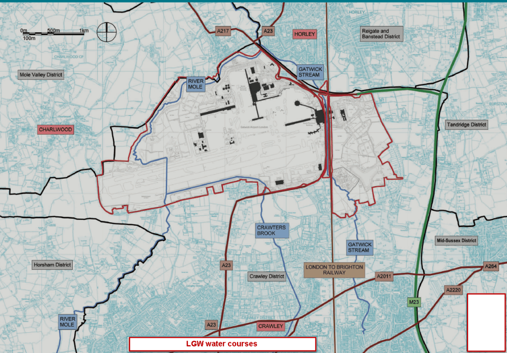
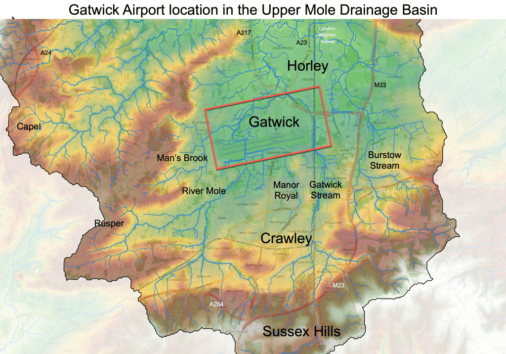
Gatwick Airport sits across the flood plains of the Upper Mole and several tributaries including Man’s Brook, Crawters Brook, Gatwick Stream and sections of Burstow Stream. Several of these stream join the River Mole in the airport environs.
The airport is located in a low, flat basin surrounded by wooded hills and countryside that makes up the higher ground forming the watershed of the Upper Mole catchment.
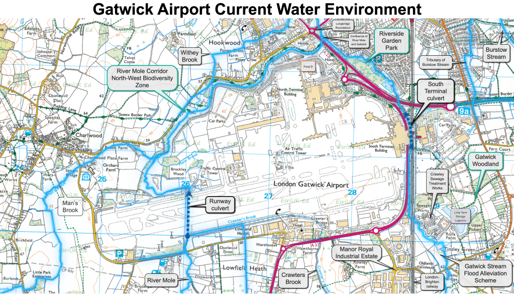
Gatwick’s rivers flow from countryside areas around Rusper, Ifield, Charlwood, Buchan Country Park, Tilgate Park and Worth Forest before entering heavily modified channels through the built up areas around Crawley and Manor Royal industrial estate. Let’s review the status of the two major rivers, the Upper River Mole and the Gatwick Stream.
The River Mole
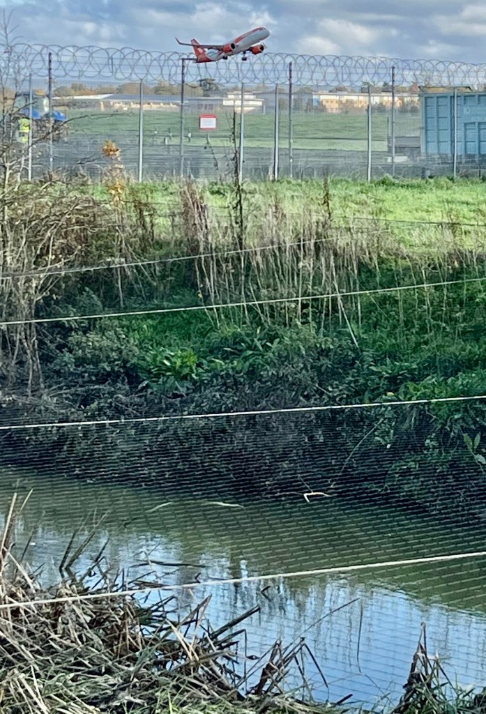
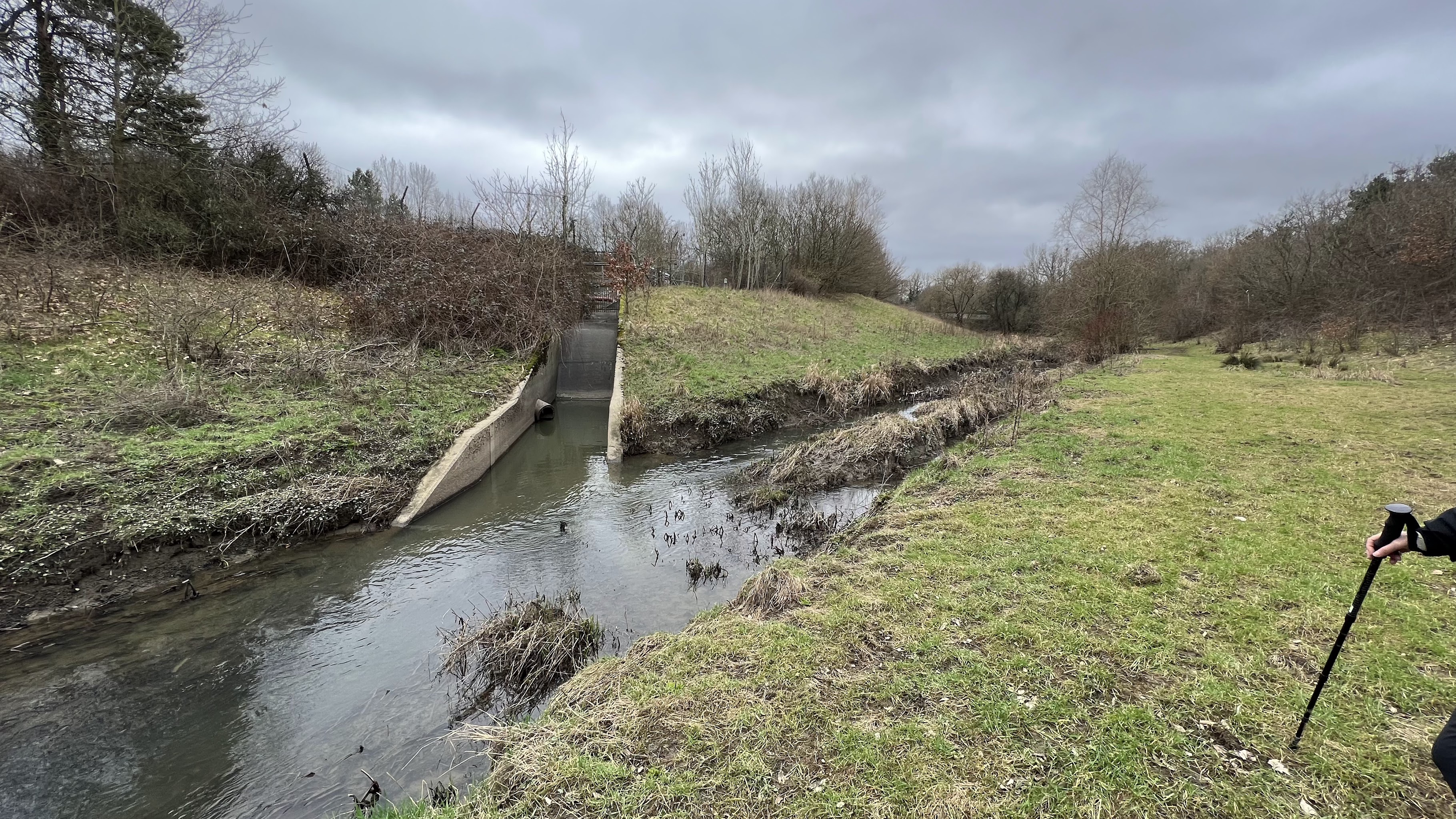
The River Mole itself enters the airport from the south across Lowfield Heath and is joined by Crawters Brook from the east just before flowing into a culvert under the runway.
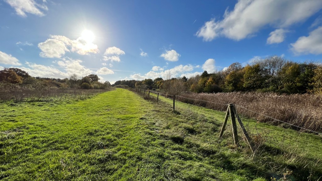
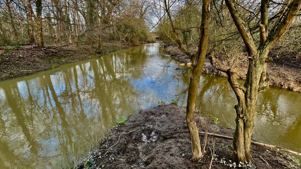
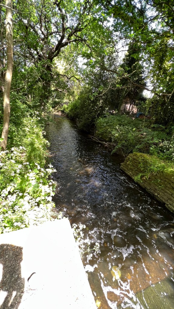
The river emerges from the runway culvert into a section which has been realigned a few times, most recently in 2000. This realigned section has been managed as an important ecological corridor known as the North West Zone Biodiversity Area. Gatwick ecologists in partnership with Gatwick Greenspace have managed the zone to become a prized area of woodland, open grassy areas, wetland and narrow flood plains. There have been notable successes in conserving several important species.
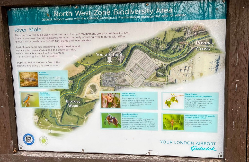
This corridor of land is enjoyed by local people as one of the most accessible parts of the River Mole. The corridor links, somewhat awkwardly (more on that later), to the wider countryside footpath network towards Charlwood and beyond. The Northern Runway Project has plans to extend the corridor open to people by the construction of a flood compensation area in the Museum Field. Fortunately, the biodiversity zone is not otherwise directly impacted by the project except for impacts during construction of the Museum Field flood compensation area and the restoration of the flood plain area downstream of the extended runway culvert.
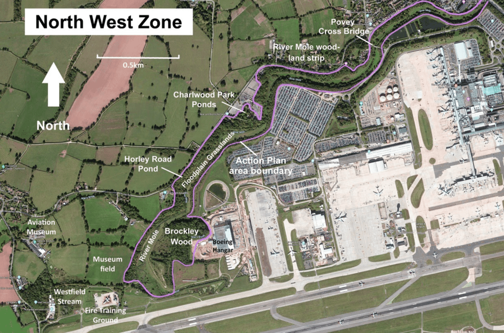
Man’s Brook joins the River Mole from Charlwood part way along the zone. The realigned biodiversity zone ends where the river flows under the A23 where it briefly flows into Riverside Garden Park before being joined by the Gatwick Stream and continuing north under Longbridge roundabout.
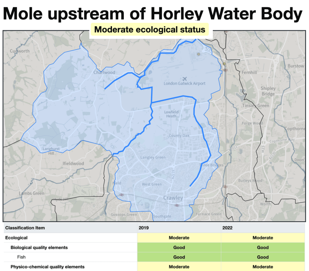
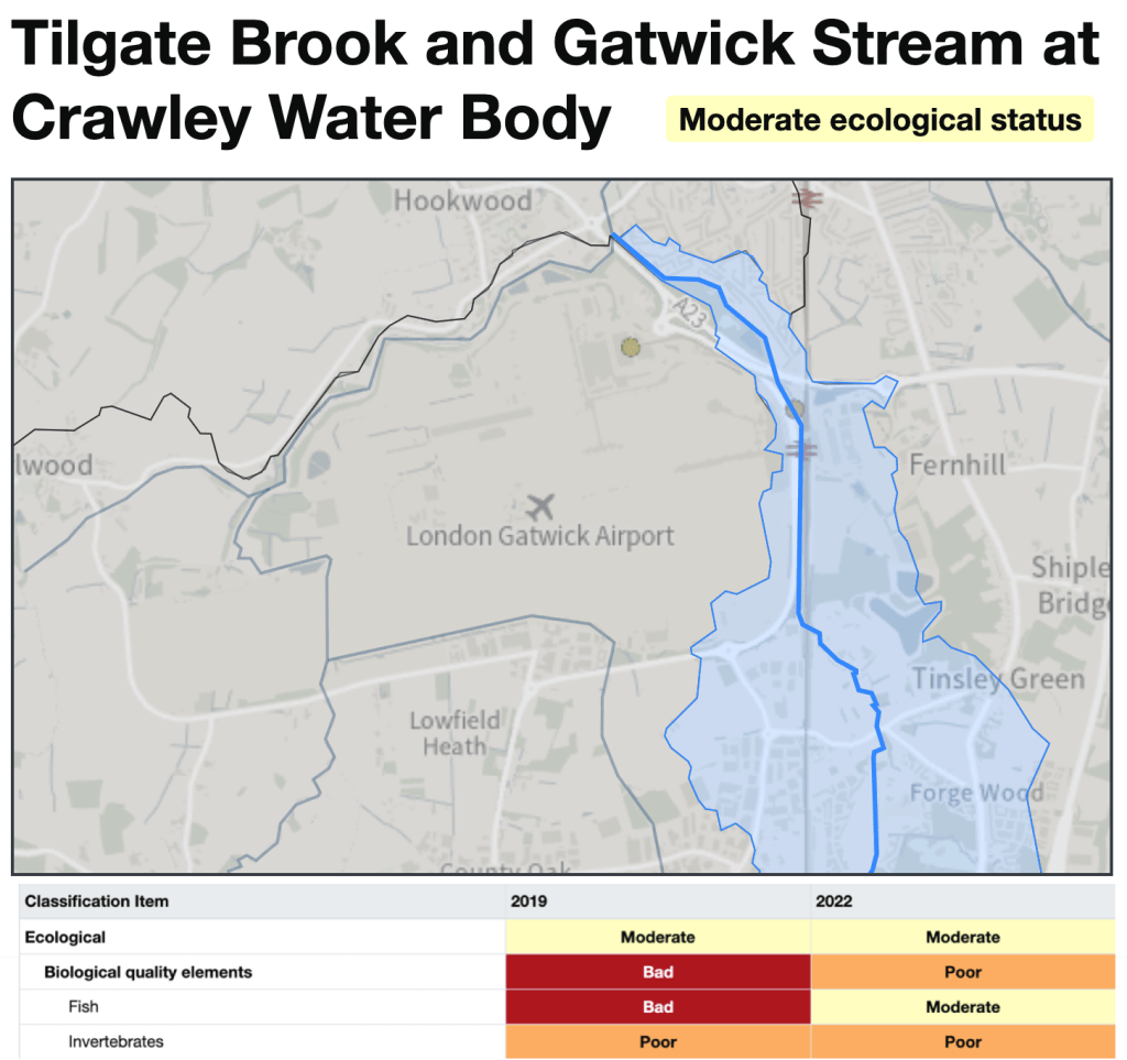
Overall, the water quality in the River Mole through this area is Moderate with some Good biological elements. In 2016 this stretch of river had Good ecological status but declined to Moderate from 2019 where it remains after the latest EA testing in 2022. As with all UK rivers, the Mole fails all Chemical substance status.
The aim to return the river back to Good ecological health must be central to the Northern Runway project and is integral to planning guidance. The planned inclusion of several additional treatment and attenuation schemes as well as the retention and in some places extension of riparian habitat could make this possible alongside new deicer processing and water storage arrangements. There are opportunities for local community groups to work with Gatwick Airport to drive forward improvements. Indeed, the soon-to-launch SERT scheme to “Mend the Upper Mole” has a focus on Gatwick Stream and is in partnership with River Mole River Watch with support from Gatwick Airport, so this engagement will hopefully build river improvements into the future.
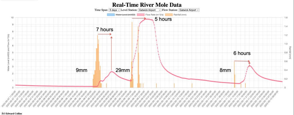
The Upper Mole is extremely flashy which means that it rises and falls in as little as a few hours after rainfall.
The catchment, including much of Crawley, Ifield, Bewbush and Rusper, has highly modified water courses. In some places tributaries through Crawley are straightened engineered channels which increase rapid runoff and shorten lag times in addition to reducing biodiversity. There are no flood defence schemes on the Upper Mole other than those designed in-situ around engineered channels and at Ifield Mill Pond where some works have been carried out to mitigate flood response (local anecdotal reports suggest less flooding now occurs across Ifield Meadows than some decades ago).
We will see that the Northern Runway Project has promising plans to improve the river channel where the River Mole exits the extended runway culvert.
Gatwick Stream
The Gatwick Stream flows into the airport from the south east at Tinsley Green. The Gatwick Stream receives effluent from Crawley Sewage Treatment Works.
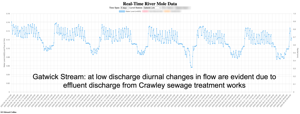
During low flow, much of the volume of discharge in the stream is comprised of treated effluent discharged from the sewage treatment works. This shows up as daily “tides” of treated effluent causing rhythmic rises and falls in the discharge of the Gatwick Stream at the gauging station at Gatwick Link.
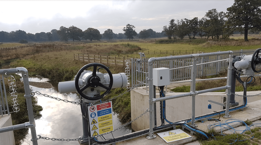
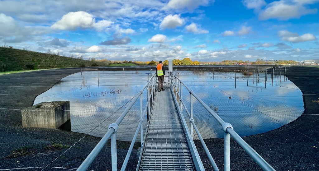
In contrast to the River Mole itself (which flows from the West and SW of the catchment from Rusper and Ifield), the Gatwick Stream, (flowing from the south), has several flood defences which make up the Upper Mole Flood Alleviation Scheme (UMFAS), funded partly by Gatwick Airport. A recent addition to UMFAS is the Gatwick Flood Alleviation Scheme. The Gatwick FAS has a large detention pond designed to temporarily store flood water at times of exceptional discharge to reduce the risk of the culvert under the South Terminal being overwhelmed during flooding. The original culvert under the South Terminal was built too small for the intensity of rainfall and magnitude of flooding so the FAS was designed to mitigate the risk up to a 1:100 year flood event.
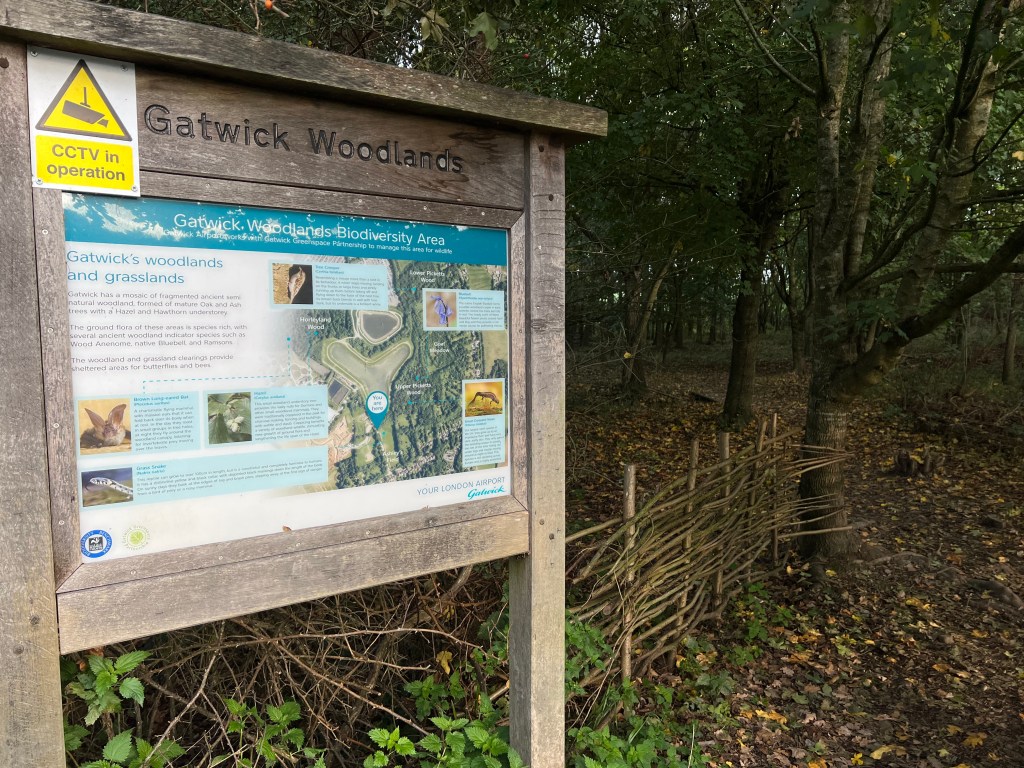
Surrounding the Gatwick FAS and Crawley Sewage Works are the Gatwick Woodlands. This is a patchwork of managed woodland that improves habitat locally and increases natural interception and storage in an area dominated by development. One of Gatwick’s ten key objectives in its’ Decade of Change policy is to..
Have a sector-leading ‘net gain’ approach to protecting and enhancing biodiversity and habitats on the airport estate, including zero use of pesticides by 2030; and support biodiversity partnerships in our region.
decade-of-change-policy to 2030
The woodlands provide footpaths connecting into a network around the airport that includes the Sussex Border Path with somewhat convoluted links to Horley Riverside. Whilst not part of the Project yet, an important additional aim to drive for here should be to create a “Gatwick Circuit Path” as part of the Northern Runway Project. Existing paths could be used with improvements to signage and some upgrades to road and stream crossings creating a contiguous countryside escape connecting habitats and rivers around the airport. This would be an enormously positive and welcome addition to the plans.
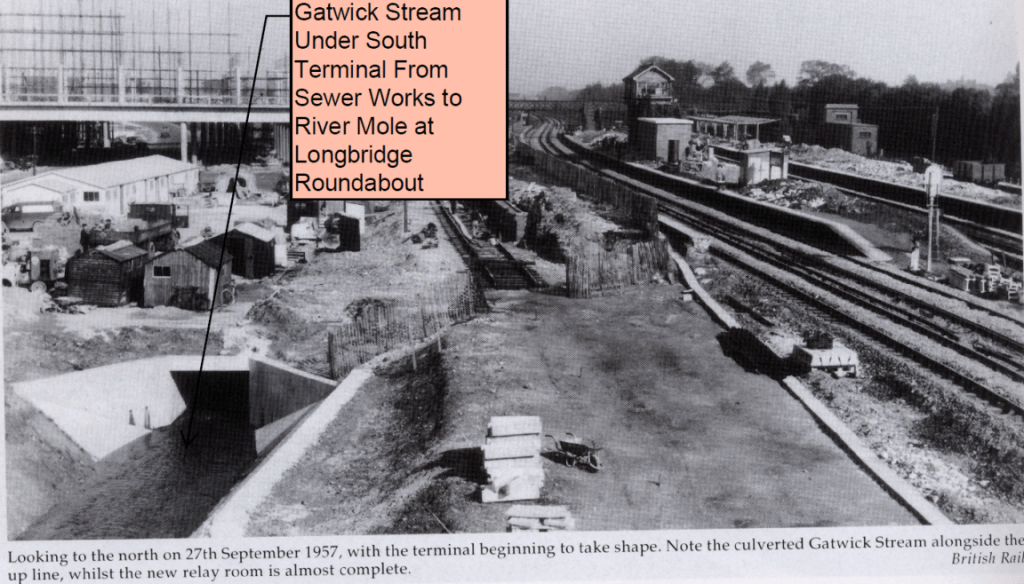
The Gatwick Stream itself flows into a culvert which passes under the South Terminal. The culvert was built in the 1950’s but turned out undersized for current peak flood events. Hence the need for the Gatwick FAS.
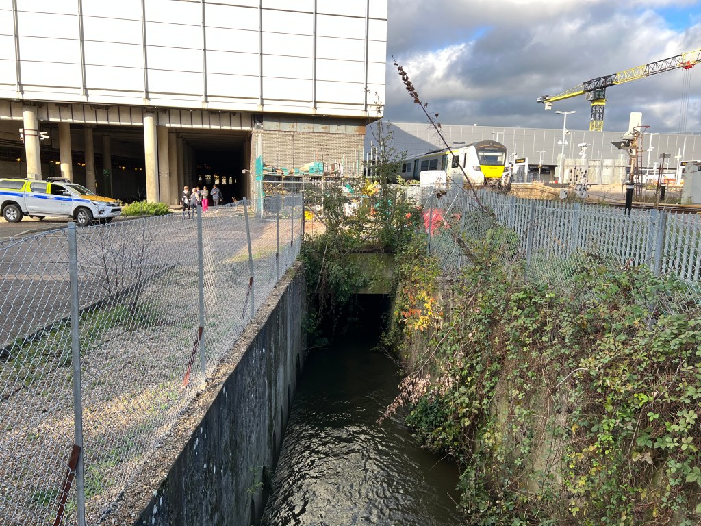
The Gatwick Stream emerges into the Riverside Garden Park which is set alongside the A23 to the south of Horley. This much loved and well used park is popular with families, anglers and river groups.
The water quality in the Gatwick Stream is assessed as Moderate but with Poor or Bad elements especially impacting fish. Reasons for Not Achieving Good ecological status outlined in the Catchment Data Explorer specify “physical modifications” and urban and industrial diffuse sources. https://environment.data.gov.uk/catchment-planning/WaterBody/GB106039017500
Existing and Future Flood Risk at Gatwick Airport
Gatwick is located in a flood risk zone. Below is an outline of flood risk management strategies employed in recent years.
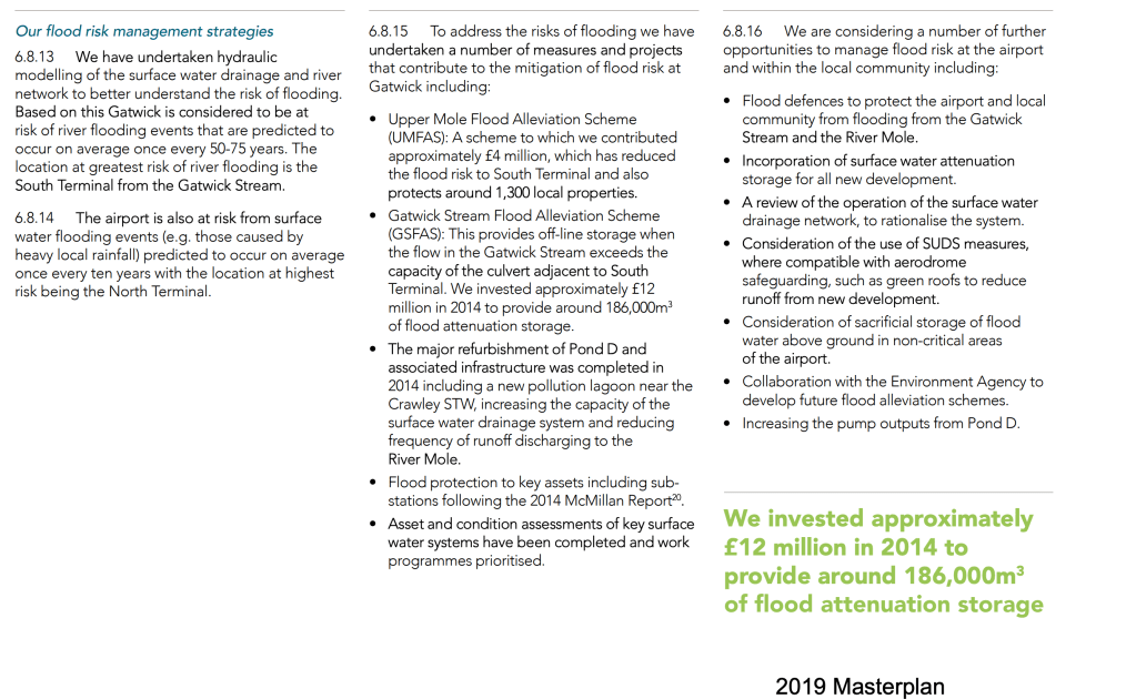
The Runway Project will entail an expansion of impermeable hard surfaces from the widening of the runway, additional car parking and widening of the A23 and attendant junctions. Without mitigation this expansion of impermeable surfaces would cause an increase in the rate and volume of runoff and risk conveying more surface pollutants into water courses.
Large parts of the airport are shown to be in Flood Zone 2 and 3 meaning these locations are at medium and high risk of flooding respectively.
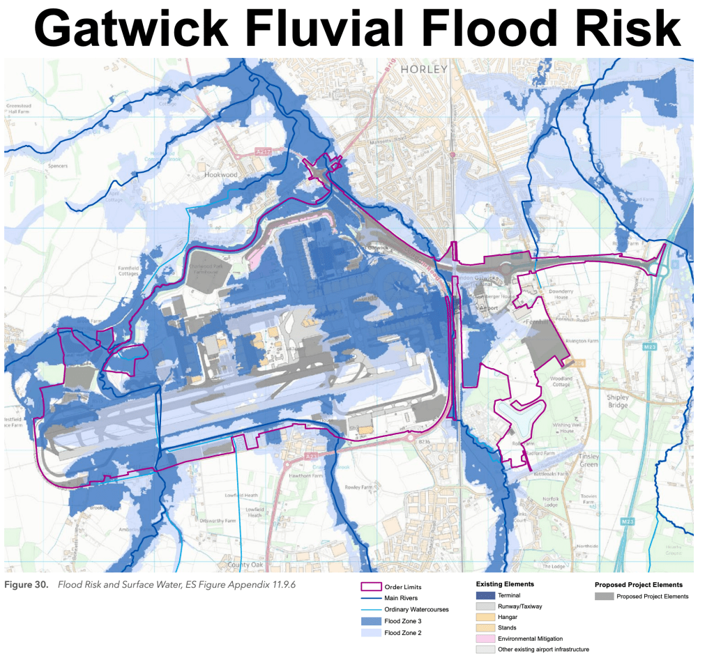
Dark blue areas on the map are in Flood Zone 3. These are termed “High risk zones” which means they are at risk of flooding in 1% AEP events (Annual Exceedence Probability) which means events with a return period of 1 in 100 years. Such an event occurred in 2013/14 when the airport was put out of action for a time due to flooding.
Light blue areas on the map above are in Flood Zone 2. These are termed “Medium risk zones” which means they are at risk of flooding from less frequent events with between 1% and 0.1% AEP. These rare but major events have return periods between 1 in 100 and 1 in 1000 years. Such long return periods might seem unnecessary to consider but recent extreme floods in Europe with return periods running into many hundreds or thousands of years are happening more frequently due to climate change. For example, attribution studies for the extreme floods in Germany 2021 calculated a return period of 15,000 years for the local area impacted and a 500 year return period for the wider region experiencing heavy rainfall.
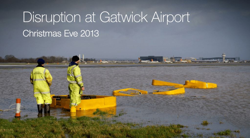
The UK MetOffice is recording an increasing number of days of excessive rainfall, including over 200mm in one day. The Mole catchment has had gauges record a few days with locations recording around 100mm since 1950, associated with the storm in 1968. In our catchment 100mm in a day equates to around a 150-200 year storm depending on the spatial extent of maximum rainfall. We have not yet recorded 200mm in 24hours. If such an event occurred it would have a return period of over 5000 years!
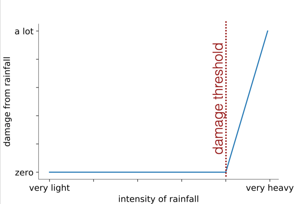
It is worth remembering that damage from rainfall and flooding tends to increase rapidly above certain ill-defined thresholds. Often little damage is recorded below such thresholds but impacts rapidly increase above them. Taking a resilient approach to flood risk by planning mitigation for these rare extreme events which exceed the standard 100 year flood risk mitigation would seem to be more appropriate for nationally important infrastructure such as Gatwick airport which is already at significant risk of flooding. Natural Flood Management can markedly reduce flood risk and would be a highly appropriate addition to the Northern Runway Project in upstream catchments such as Baldhorns Brook, Broadfield and Bewbush Brooks, Stanford Brook and Burstow Stream. For more on Natural Flood Management in the Mole catchment please refer to this post I wrote last year
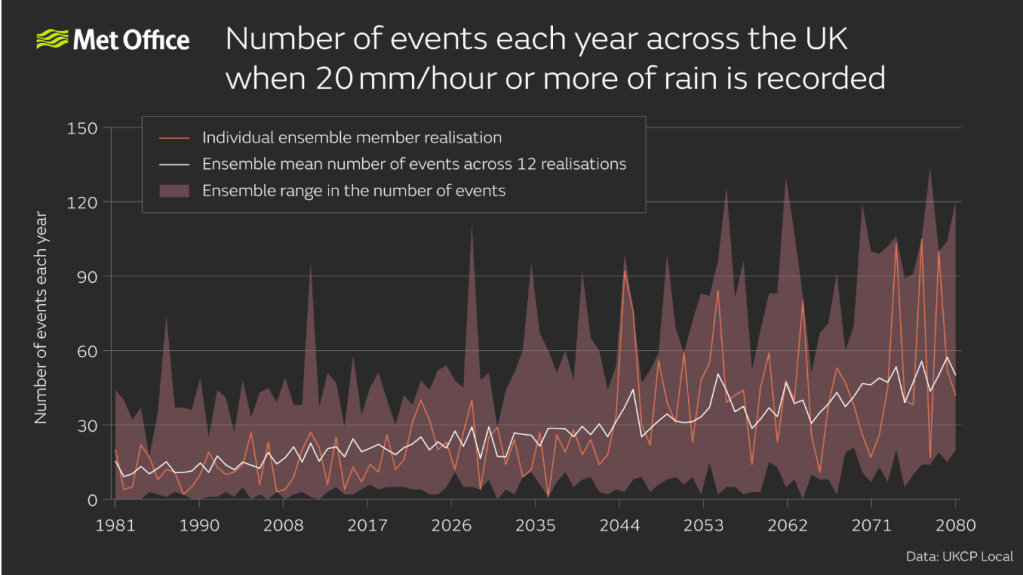
Of course, climate change is predicted to increase the intensity of rainfall. This means that extreme surface water flooding events above those experienced historically with lengthy return periods of thousands of years are forecast to become more likely. As shown above, storms with 20mm/hr rainfall intensity are predicted to become more frequent. If such a storm persisted for 3 hours across the Mole catchment it would deliver 60mm of rain equating to a 430 year storm (a single point location recording the same would be an 83 year return period storm). So flood risk is predicted to increase with climate change and Gatwick is at significant risk.
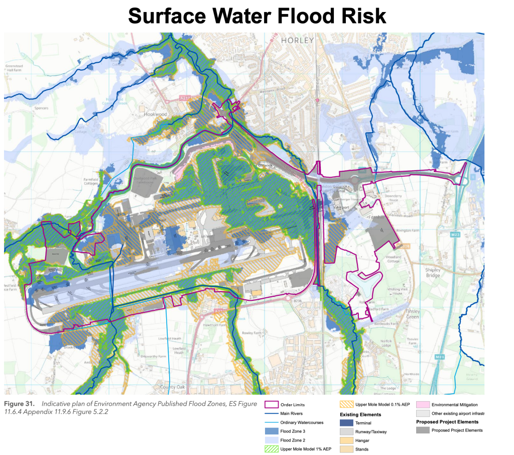
The map shows existing Risk of Surface Water Flooding (RoSWF) from heavy rainfall combined with Flood Zones 2 and 3 caused by fluvial (River) flooding. In practice the two types of flooding, river and surface water, are often indistinguishable as many of the areas prone to surface water flooding are at low points in the airport around water courses which are also prone to river flooding.
The plans for the Northern Runway project, if completed to a high quality and maintained in perpetuity, could somewhat improve upon existing flood mitigation levels because various schemes add flood compensation areas and improves attenuation with more flood storage. Overall this is modelled to reduce downstream flooding somewhat.
However, there is some concern over the choice to allocate a lifespan of just 40 years to the airfield element of the project. Government guidance suggests that essential transport infrastructure falls into one of the highest land use vulnerability classifications and, as such, recommends “a period of at least 75 years… to form a starting point” for applying policies on flood risk and calculating climate change uplift. This means that the choice of 40 years to apply climate change allowances would appear to be inadequate. The reason provided by Gatwick for allocating 40 years to the airfield lifespan suggests the likely rapid change to aviation in that time period renders mitigating for extremes further into the future is unsound and not cost effective. However, what will not change is the risk of flooding..which is predicted to worsen in that time period. More clarification of why this short lifespan was chosen is needed. (ref: https://www.gov.uk/guidance/flood-risk-and-coastal-change#planning-and-flood-risk Paragraph: 006 Reference ID: 7-006-20220825 Revision date: 25 08 2022)
Northern Runway Project: Plans for Flood Risk Mitigation and Water Quality Management
There are three main elements to flood mitigation outlined in the Northern Runway project Flood Risk Assessments and Environmental Statements. Here we can also include a review of how runoff and water quality are treated because the “treatment train” in sustainable urban drainage is integral to attenuation and flood control design.
- Fluvial (river) flood risk and water quality mitigation measures
- Surface Water (rain) flood mitigation and water quality treatment measures
- Highways: flood mitigation and runoff treatment
The Northern Runway Project plans to move the runway 12 metres to the north which impacts the existing River Mole culvert and requires it to be extended. However, the project doesn’t extend the footprint of the airport beyond the current boundaries. Few watercourses are therefore directly impacted and there is no wholesale river realignment required to accommodate the new runway. Whilst there is an extension to the Burstow tributary culvert in the east there are a number of plans that seek to improve river and flood plain connectivity and habitat leading to some possible improvements in flood mitigation and water quality.
The FRA models show that the outcome of planned mitigation schemes should result in “no increase in flood risk and some beneficial impacts on reducing flooding downstream”.
“no increase in flood risk and some beneficial impacts on reducing flooding downstream”.
Planning docs FRA
Furthermore, the FRA promises that flood plain compensation will mitigate any loss of flood plain and add storage. Importantly, flood mitigation is also planned to be in place before any corresponding loss of floodplain occurs.
The Flood Risk Assessment demonstrates that through the provision of additional attenuation storage and floodplain compensatory storage the Project would not increase flood risk to other parties for its lifetime taking climate change into account (but see note above on short 40 year lifespan). Indeed, hydraulic modelling for 1% AEP +12% and 20% climate change allowance shows reduced flooding from the Project on residential properties and industrial properties compared with the existing risk. Here then, the hydraulic models suggest that the Project will have a moderate to major beneficial impact downstream. This is a positive step-up in flood resilience and is a welcome part of the Northern Runway Project.
The FRA also states that the impact on flooding inside the airport is modestly improved with most areas benefiting from reduced design flood depths by up to 100mm adjacent to the runway and 10mm for the South Terminal. However, small parts of the airport are modelled to experience an increased flood risk, for example the Taxiway and new Fire Training Ground.
The above improvements are due to several proposed measures for new and upgraded runoff attenuation and flood mitigation schemes around the airport. These schemes will also benefit the treatment of runoff which could see improved water quality entering the Mole. In the specific case of car parks water treatment is currently considered “insufficient”, so improvements in this regard are also very good news.
What follows is a list of the key upgrades to fluvial, surface water and highways flood mitigation and water treatment schemes.
1.Fluvial Flood Risk and Water Quality Mitigation Measures
The Project proposes several new fluvial flood risk mitigation measures which are listed below. “The Project produces widespread betterment to flood risk across the airport”.
- Realignment and naturalisation of the River Mole downstream (north) of the northern runway. The re-wiggling of the River Mole and reconnection to a flood plain will increase wetland storage during times of high discharge.
- Museum Field floodplain compensation area (FCA): lowered by 2.6m; excavate >80,000 m3 material. This will act as a temporary detention basin designed to store flood water at times of peak discharge in the River Mole as it exits the runway culvert into the NW Zone. Retaining flood water until the peak subsides is designed to lower flood risk downstream.
- Car Park X will act as a Flood Compensation Area. The excavation of 28,000m3 will store flood peaks to lower flood risk downstream.
- Two syphons beneath taxiway Yankee and the western end-around taxiway to maintain floodplain connectivity.
- Six syphons beneath the northwest noise mitigation feature to maintain floodplain connectivity.
- Six culverts beneath the active travel path associated with surface access works between Car Park Y and the A23.
Let’s look at the first two of these flood mitigation schemes in more detail:
Realignment and naturalisation of the River Mole downstream of the northern runway
The River Mole is currently a modified straight channel as it exits the runway culvert. While attenuation Pond A (nearest existing runway) will be removed, the plan is to more than compensate for this loss by increasing the area of available flood plain by wiggling the river into a new course with sinuous meanders whilst retaining part of the old course for use as flood plain storage.
The wiggling of the river across the flood plain should lead to improved biodiversity and water quality. With ongoing ecological management a successful river habitat reconstruction seems to be possible in line with the success story of the existing Biodiversity Zone to which it will be seamlessly connected.
A disadvantage of further wiggling of the Mole is to increase channel length by 297m. This has the effect of reducing the existing shallow gradient from 1:1250 to 1:1890 and slowing flow. The possible reduction in water velocity risks deposition along this stretch but also enhanced erosion downstream. It might also risk slack velocity in low flow conditions which could be a problem for dissolved oxygen levels in the river. This stretch has suffered oxygen crashes recently (May 2023) and so ways to improve flow and water quality should be sought in the new channel arrangements to increase dissolved oxygen.
Various mitigations are proposed which include the selection of sediment size to reduce risk of deposition and erosion downstream and wetland planting to improve water quality.
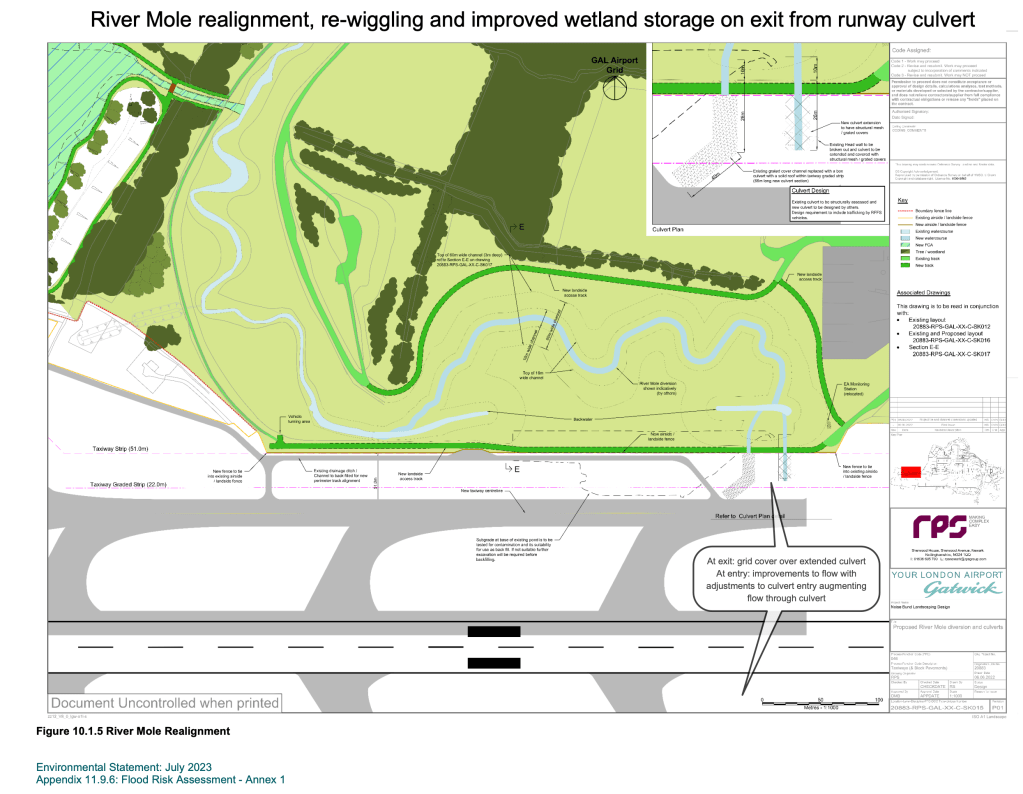
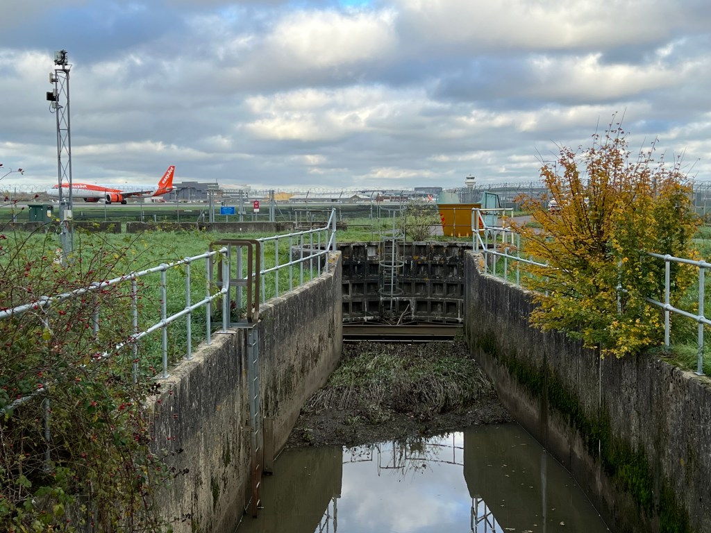
The extended culvert across the new runway is planned with a grid to add light and a new weir will improve low flow and fish passage. Overall these are considered to have moderately beneficial improvements.
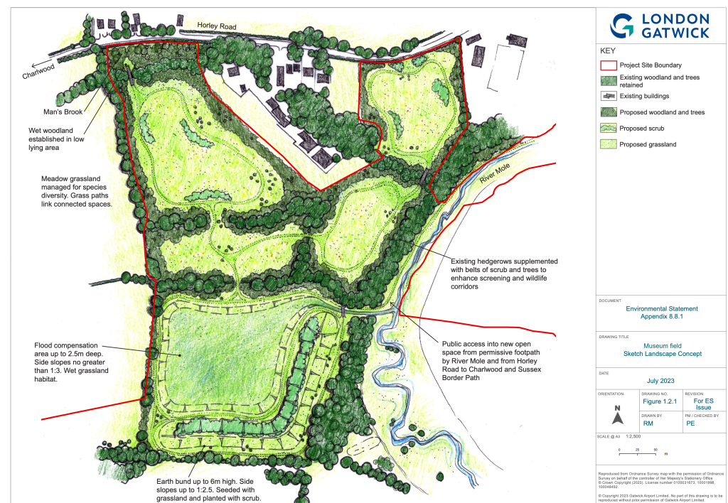
Museum Field Flood Compensation Area
Just downstream of the culvert is the Museum Field. The plan is to turn this into a Flood Plain Compensation Area (FCA). Land will be lowered by 2.6 metres with over 80,000m3 of excavated material, the spoil being transported to Pentagon Field which is on the east side of the airport on the Balcombe Road. Spoil will be transported using internal airport roads rather than public highways to reduce congestion. The Museum Field detention basin will be used for flood storage during extreme flood events. The water will be managed so that it fills as the river reaches a certain level, probably flowing across a spillway into the basin. Water will reside temporarily in the basin and drain slowly into the river afterwards, at greenfield rates. The slow controlled rate of return flow is important to avoid raising flood peaks downstream (see note below on desynchronising flood peaks).
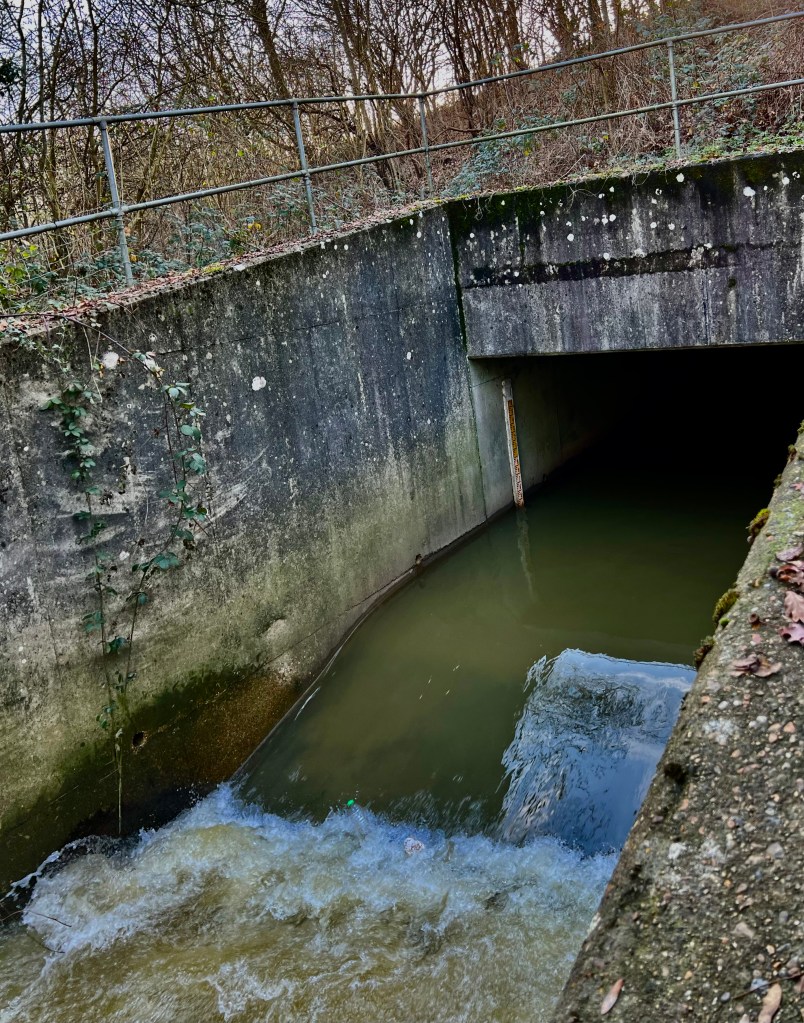
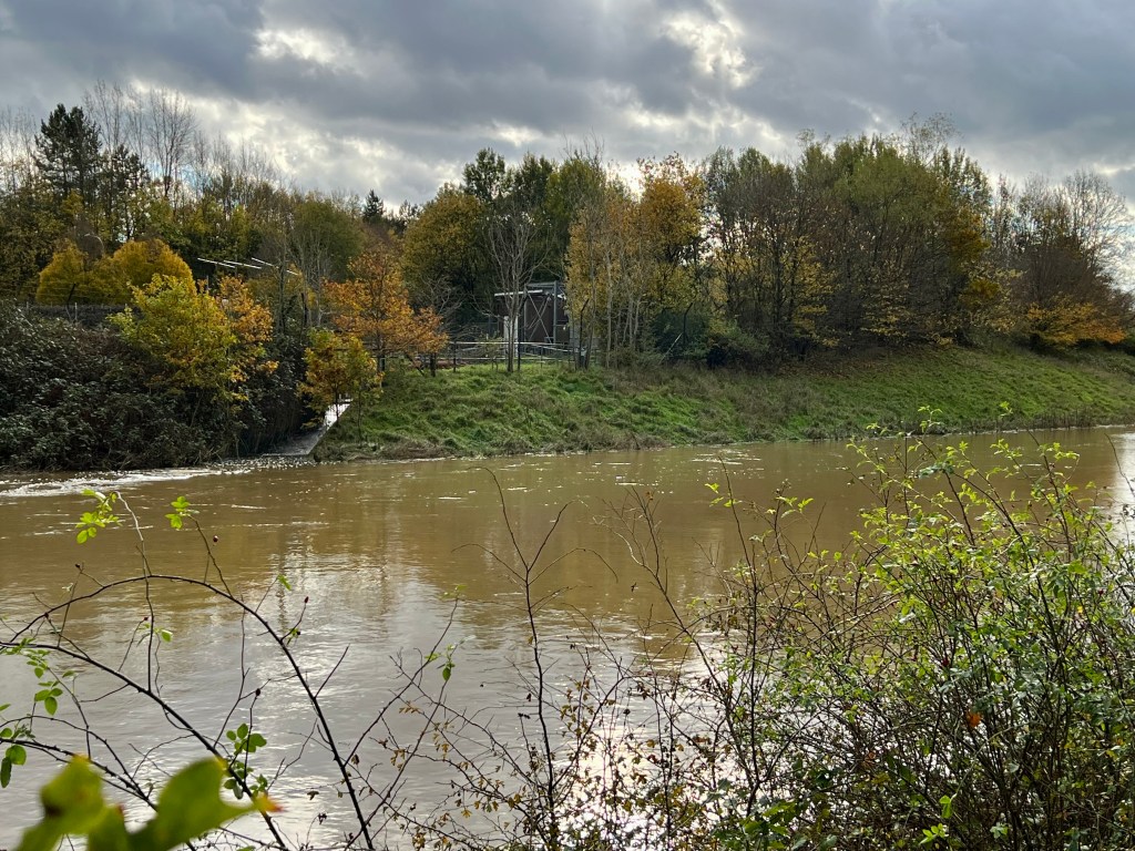
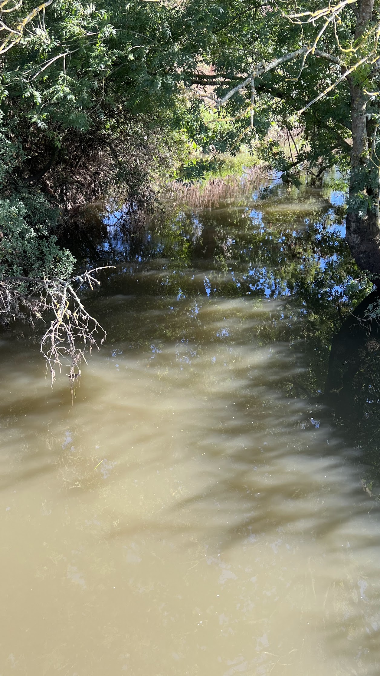
The substantial detention basin (for comparison the Gatwick FAS is 100,000 m3) is much needed to address any increase in downstream flood risk caused by the expansion of impermeable surfaces in the runway project. The original realigned section of the River Mole was skewed away from the natural channel so the gradient here is already shallow. This means that water moves slowly through this reach. There is a hypothetical risk of the valley cross section being overwhelmed in extreme conditions. The photo below was taken opposite D Pond showing a modest storm discharge of approximately 8 cumecs flowing down the realigned section of the Mole around Gatwick following a storm on 16-17 November 2022. Underneath shows a photo, closer up, of the same location in “normal” conditions.
The maximum recorded discharge of the Mole in it’s original channel through Gatwick was 22 cumecs in 1968. This shows that any additional flood plain compensation is crucial here to address the risk of these extreme flows exceeding “bankfull” and overwhelming the modest valley cross section with a risk of spilling into adjacent local catchments in Hookwood.
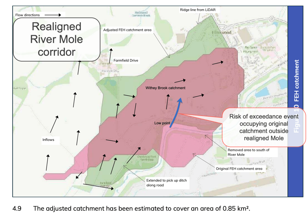
The theoretical risk, albeit low probability, is important because of planned housing development in the adjacent Withey Brook valley, potentially increasing the population at risk from such an extreme event. This at least should be an area for additional hydraulic modelling to assess impacts.
The Museum Field itself will extend additional access for the public to enjoy open space further along the Mole corridor. Overall the Museum Field and changes to the Mole channel at the runway culvert end is a positive addition to airport water management.
However, one aspect of flood compensation and attenuation not clearly covered in the FRA is…
Clarifying de-synchronisation of flood peaks
Detailed flood mitigation plans will need to clarify greenfield runoff rates as well as the proposed storage time of the Museum Field FCA so that attenuation does not inadvertently synchronise with flood peaks arriving from tributaries downstream.
For example, the Gatwick Stream usually peaks around 1.5 hours after the River Mole so attenuation from the Museum Field must take this into account to avoid inadvertently increasing flood peaks at the confluence in Riverside Gardens. So called “de-synchronisation” of flood peaks across the catchment is important to ensure a reduction in flooding downstream. Currently, there does not seem to be explicit reference to such modelling in the plans and there ought to be modelling to show that this risk has been fully accounted for.
Improve public access to wider countryside
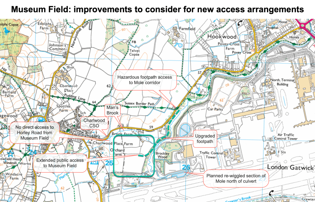
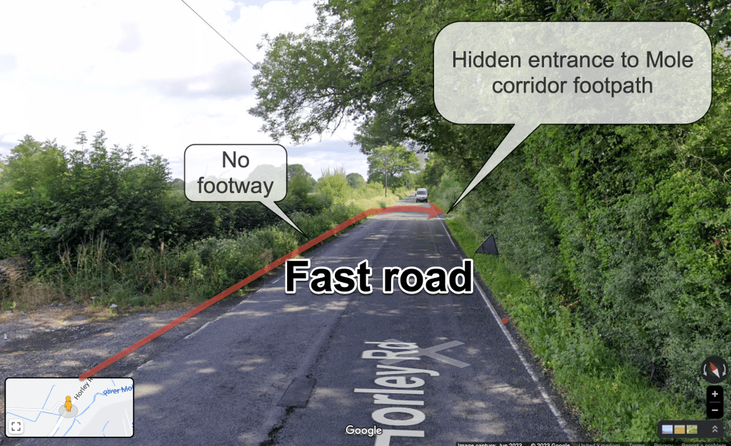
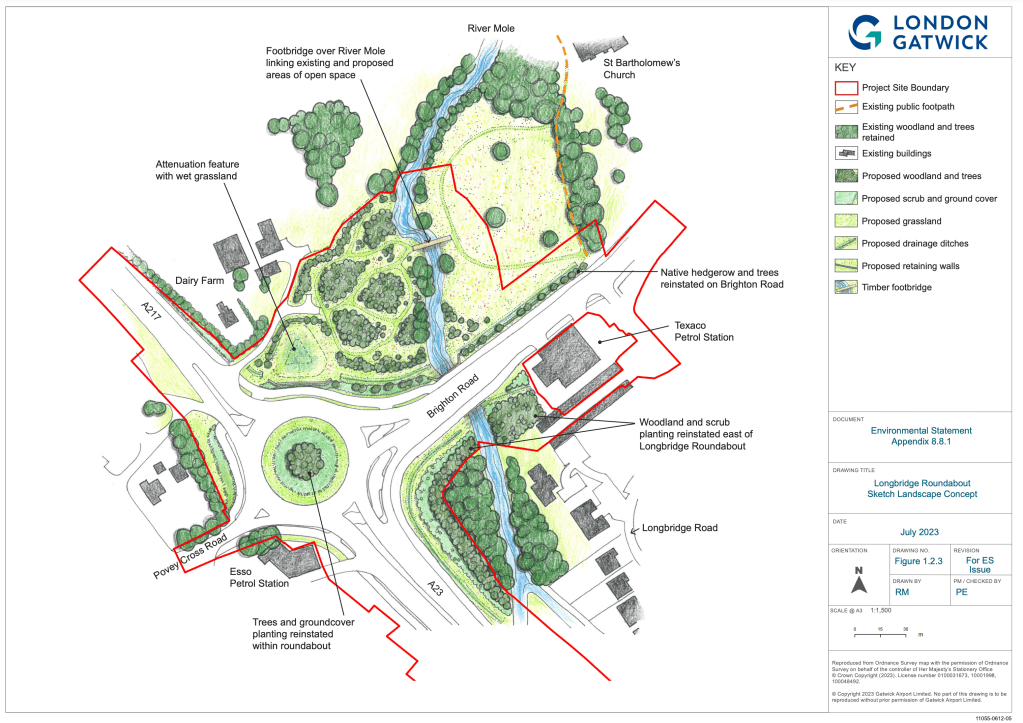
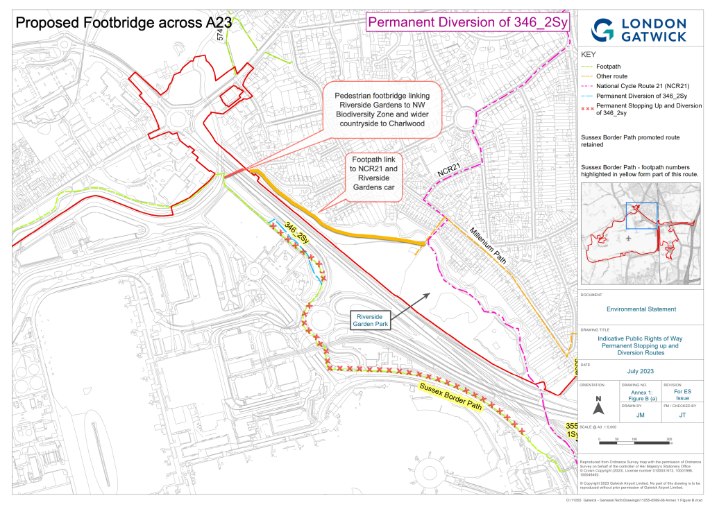
Further improvements to footpath access to the wider countryside should be included in detailed planning to achieve safe integration with public rights of way outside the airport. Consideration of wider public benefits ought to be part of the Northern Runway Project. For example, elements of the path across to Charlwood, especially the crossing of Horley Road, are poorly designed and not adequately maintained. In particular, there is a hazardous road crossing for pedestrians due to an absence of a footpath and unclear entrance to the Mole corridor footpath on the Horley Road.
Overall the Northern Runway project has significant opportunities to address the NPPF’s requirements as set out below. However, improvements to wider local public access promoting health and well-being and active travel ought to be more explicitly a part of the Project.
2.Surface Water Flood Mitigation and Water Quality Treatment Measures
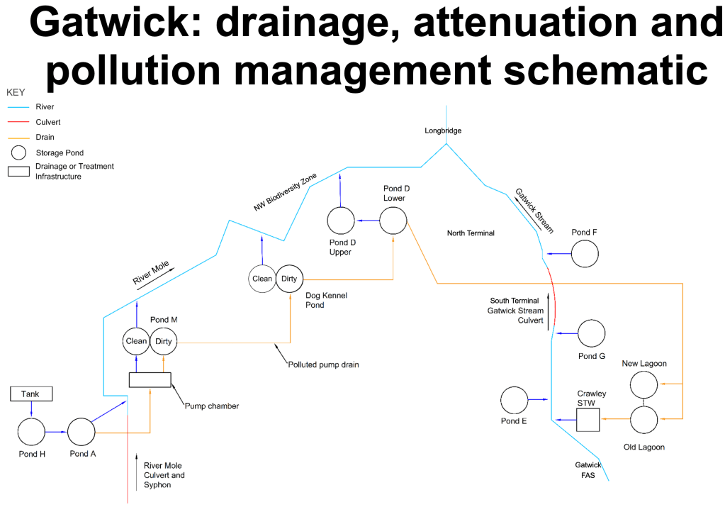
Historically, Gatwick Airport has performed well in mitigating flood and pollution risks from surface water runoff off runways and hard standings by a sophisticated and ever-expanding network of attenuation ponds, syphons and pumps that both slow down the rate runoff, store the extra volume and test the water quality for separation into further treatment pathways or controlled release into local water courses.
The Runway Project provides opportunities to build on existing water quality management.
Moving forward, with regard to the Northern Runway Project, National Planning Guidance requires that :
‘…any project that is classified as ‘essential infrastructure’ and proposed to be located in Flood Zone 3a or b should be designed and constructed to remain operational and safe for users in times of flood…’ (Paragraph 5.109 of the NNNPS).
ES Appendix 11.9.6 FRA Para 5.109
Furthermore, the Exception Test should demonstrate that: ‘the development will be safe for its lifetime taking account of the vulnerability of its users’.
For the purposes of modelling changing flood risk from climate change, the lifetime of the airport is taken as 100 years while the lifetime of the runway is taken as 40 years which we have already discussed seems to be too short.
The Runway Project will add to the cover of impermeable area which risks increasing runoff. Left unmitigated the increased volume and rate of runoff into water courses would cause increased flooding and a reduction in water quality as polluted material is carried from hard surfaces into rivers.
However, the Runway Project has planned mitigation measures, including new drains, filter drains, ditches and attenuation ponds, which will limit discharges to water courses to predevelopment values and “where possible” to greenfield runoff rates. In addition, these measures will also treat the water prior to discharging into water courses.
Here are the proposed measures mentioned in the plans to mitigate surface water runoff:
- Increased attenuation storage in a new facility at Car Park Y to reduce risk of surface water flooding to the North Terminal at 1% AEP + 40% CC. Water would be pumped to Pond D.
- Increase attenuation storage within the airfield surface water drainage network
- A new surface water attenuation feature and pumping station to mitigate the additional hard standing being created in the Pond A Catchment and mitigate for the removal of Pond A.
Overall, the Flood Risk Assessment modelling finds that the provision of additional attenuation storage results in no increase or decrease in discharge volumes and total peak runoff rates as a result of the project. There is no significant impact for all events including 1% AEP plus 25% (central) for airfield and 40% (upper end) for highways.
Existing water treatment and tight airport regulation of runoff across the airport site ensures that the risk of pollution is controlled. In particular, de-icer is separated, stored in lagoons and treated at Crawley Sewage Works before discharging into the Mole. De-icer (glycol) is a serious potential pollutant of water courses and models of deicer use predict increasing amounts used with the Northern Runway Project despite warming and fewer cold days. To mitigate and improve upon existing de-icer processing, a new deicer treatment system is planned adjacent to the long term storage lagoons. This will treat 100l/s replacing the need for Thames Water to treat deicer (which is therefore at risk from discharge in storm overflows). Overall, models show the new facility should improve the management of airport runoff which is promising news.
Unfortunately, the existing treatment of runoff from car parks was assessed in Environmental Statements as being “insufficient”. This is likely down to the rapid historic growth of car parks and the self-balancing of car parks which means that runoff has been directed into surrounding ditches and water courses. According to modelling shown in the grid below, the existing treatment of surface water runoff from car parks does not treat water quality sufficiently and so there are risks that pollutants will be conveyed into rivers. The grid below identifies a number of pollutants that exceed limits. Nevertheless, the assessment goes on to state “it is anticipated that sufficient treatment for water quality will be included (in the Project) …for all car parks to provide adequate attenuation and treatment of runoff”. This is promising news which suggests that water quality can be improved and indeed the upgrades required to improve car park runoff should be cost effective. It is hoped community charities such as our River Mole River Watch will be able to work with GAL to report on these improvements as they are installed.
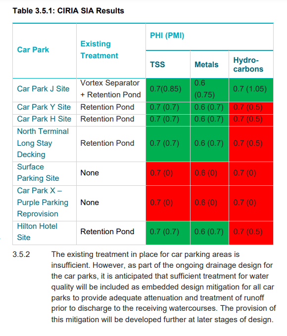
Planning documents state “New upgraded car parks will include sufficient mitigation to ensure no reduction on water quality of receiving water courses”. So we look forward to the details of drainage design for the car parks which should include upgraded treatment to improve mitigation of the pollution hazard.
Fire Risk in Car Parks
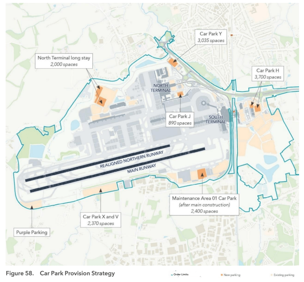
Of significant importance is the issue of vehicle fires in car parks. There will be parking for over 13,000 cars around the airport. EVs catch fire about as often as ICE vehicles but EVs are much harder to extinguish, requiring enormous amounts of water which will probably contain * fire retardant PFAS or other * contaminants which must not be allowed to enter water courses. The Northern Runway Project plans have several new car parks and some of these are planned as FCA or flood storage which presumably risk conveying runoff directly into rivers in an emergency response to fire. *Amendment: Fire fighting foam from Airfield fire service will not contain PFAS*
Fire water management does not appear to be mentioned explicitly in Environmental Statements or risk assessments. *Whilst in most cases the balancing ponds are likely to provide an opportunity to intercept contaminated flow and deal with during or after the event, nevertheless, the management of fire water to mitigate risk of river pollution, for example by locking off car parks to retain water, and other appropriate mitigations should be a part of the risk assessment.
*Updated: to include the ability of balancing ponds to mitigate some risks of fire water contamination*
3.Highways: Flood and Water Quality Mitigation Measures
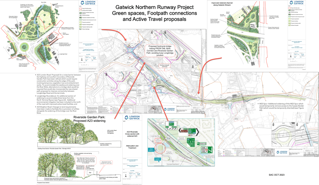
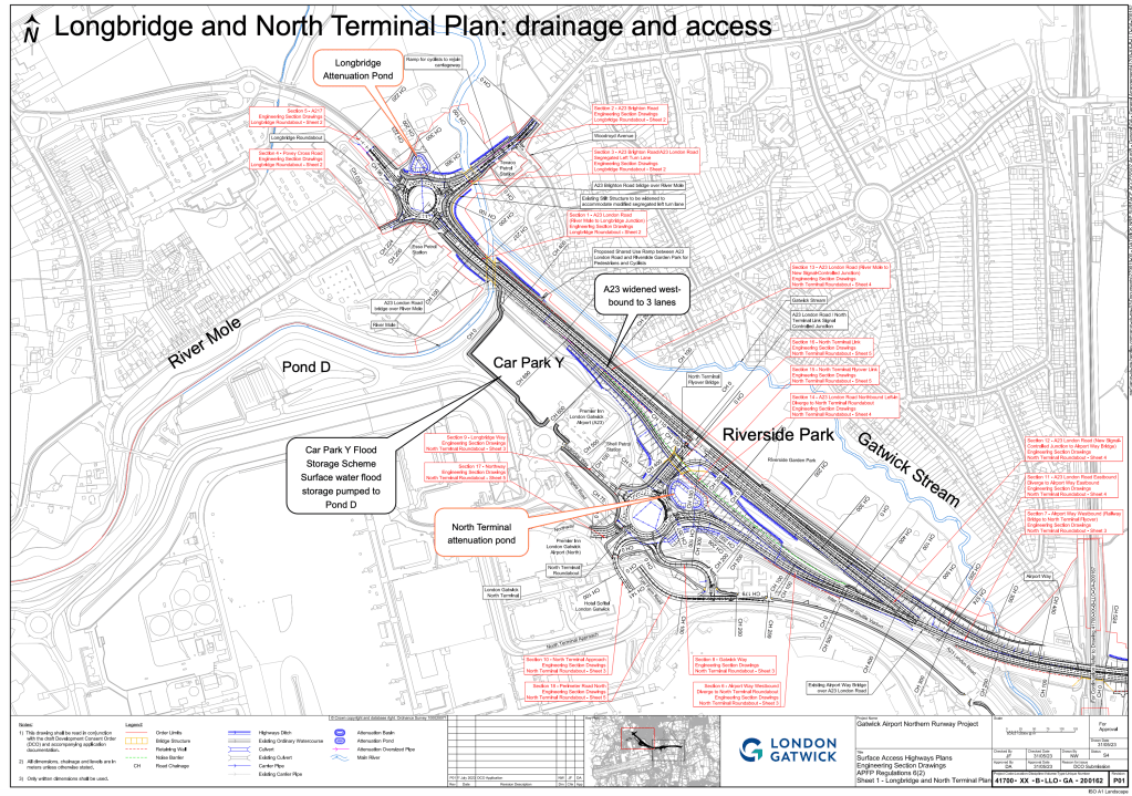
The crux of changes to the road layout involves the widening of the A23 as it approaches Longbridge Roundabout and changes to associated bridges across the Mole, along with changes to both roundabouts at North and South Terminals. These works have implications for the attenuation and treatment of runoff into the River Mole and Gatwick Stream. Details of schemes to attenuate runoff appear in plans and include those shown above on the map.
Widening and enlarging roads to accommodate more traffic could be the biggest risk to river health posed by the Project. The A23/M23 feeder road already has traffic volumes over 50,000 vehicles per day. Toxic runoff from roads is a serious risk to river water quality and public health. Relatively simple and cost effective control devices can be used to treat road runoff. We need to see more details about what these are in plans.
Plans include details about flood risk mitigation. The Highways flood mitigation plans listed below yield modelled reductions in flood risk around Longbridge and Riverside.
1. Longbridge road roundabout: widening bridge over Mole; +6.4m; Increase span by 5m
2. Highway drain to outfall via new attenuation basin
3. Church meadows: attenuation by outsized pipe.. will be new.
4. Widening bridge over Mole south side A23 by >9m
Road widening and reconfiguring of roundabouts at Longbridge and North and South Terminals include attenuation ponds and swales and tanks designed so that the Project will not increase flood risk to other parties at the 1%AEP 1 in 100 year +40%CC.
The FRA states that “Highways attenuation drains and ponds are designed to mitigate up to peak design water level for the 1% AEP”. In other words, the Highways SuDS along the A23 will be designed to mitigate the 1 in 100 year flood plus a 40% climate change allowance. Beyond this level, in exceedence events or due to blockages, excess flows will presumably be conveyed down planned routes to water courses and may risk overwhelming treatment trains. We have already mentioned that using the baseline of 100 years is too small for such a national infrastructure project.
Importantly, National Infrastructure Planning Advice states clearly that robust evidence is required to identify if there is a risk of deterioration of any element of water quality from proposed road developments. This is particularly the case with the widening of the A23/M23 feeder road and increasing traffic forecast which presents grave risks of increasing toxic runoff containing road pollutants such as poly-aromatic hydrocarbons. There are laws which state that such Priority Substances cannot be discharged in rivers.
In the Environmental Statement Appendix 11.9.2, page 4, the Northern Runway project states that they have followed the stages in the National Planning Inspectorate document to complete their assessment of the development. However, proper monitoring and testing of the existing highway outfalls should take place and made available to ensure the actual impact of proposed road development has a thorough evidence base.
Whilst the HEWRAT models suggest plans pass runoff requirements the A23, carrying over 50,000 vehicles per day, is almost certainly discharging hazardous Poly-Aromatic Hydrocarbons (PAH) into local water courses. The Project should include sampling at road runoff outfalls during rainfall events to establish the degree of pollution to update and re-run models representative of the reality on the ground. Appropriate mitigations can then be applied in the new road schemes.
Furthermore, more, details of emergency spillage control across the site both during and after construction are needed as construction will be a particularly risky time for the water courses.
Plans for the A23 are shown above. Highways improvements include filter drains, ditches, ponds, swales and tanks to store and attenuate increased runoff from highways. As mentioned, details of road runoff management must show a high quality treatment train.
Details of changes for Longbridge Roundabout include:
- Widening bridge over Mole +6.4m
- Increase span by 5m
- Highway drain to outfall via new attenuation basin
- Church Meadows: attenuation by outsized pipe.. will be new.
- Widening bridge over Mole south side A23 by >9m
Longbridge surface water drainage from roads would seek to drain runoff into receiving water courses or directly into the River Mole. There is a mention of some receiving water courses being “unknown” at this stage. This suggests local hydrology is somewhat uncertain. For example, “Outfall 13 discharges into unknown receiving water course.. more information needed on impact here (Ref 11.9.3 HEWRAT ES Appendix). Obviously local hydrology will need to be thoroughly modelled prior to final plans being approved. (Ref Highways improvements: 11.9.151)
Changes to North Terminal access arrangements will include a loss of part of Riverside Garden Park due to widening and a possible noise barrier. However, it’s not quite clear where the noise barriers will go, some plans show barriers on both sides of the A23, others only to the south. Drainage from the North and South Terminal road networks will enter the Mole and Gatwick Stream, presumably through pipes.
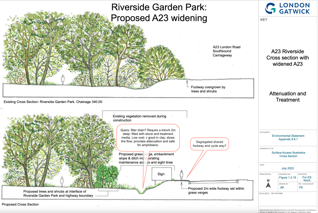
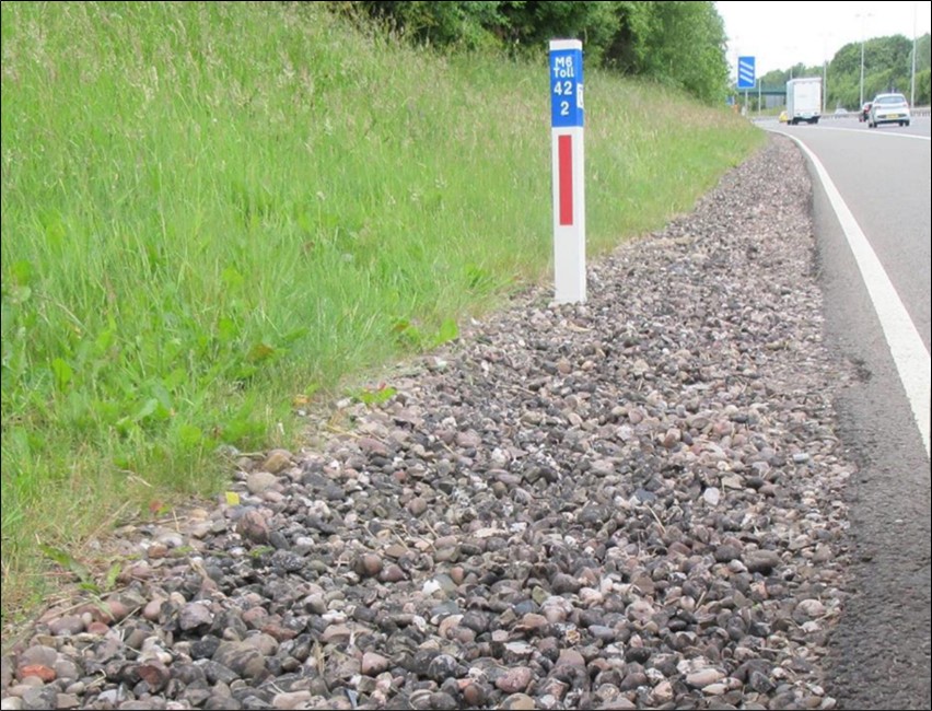
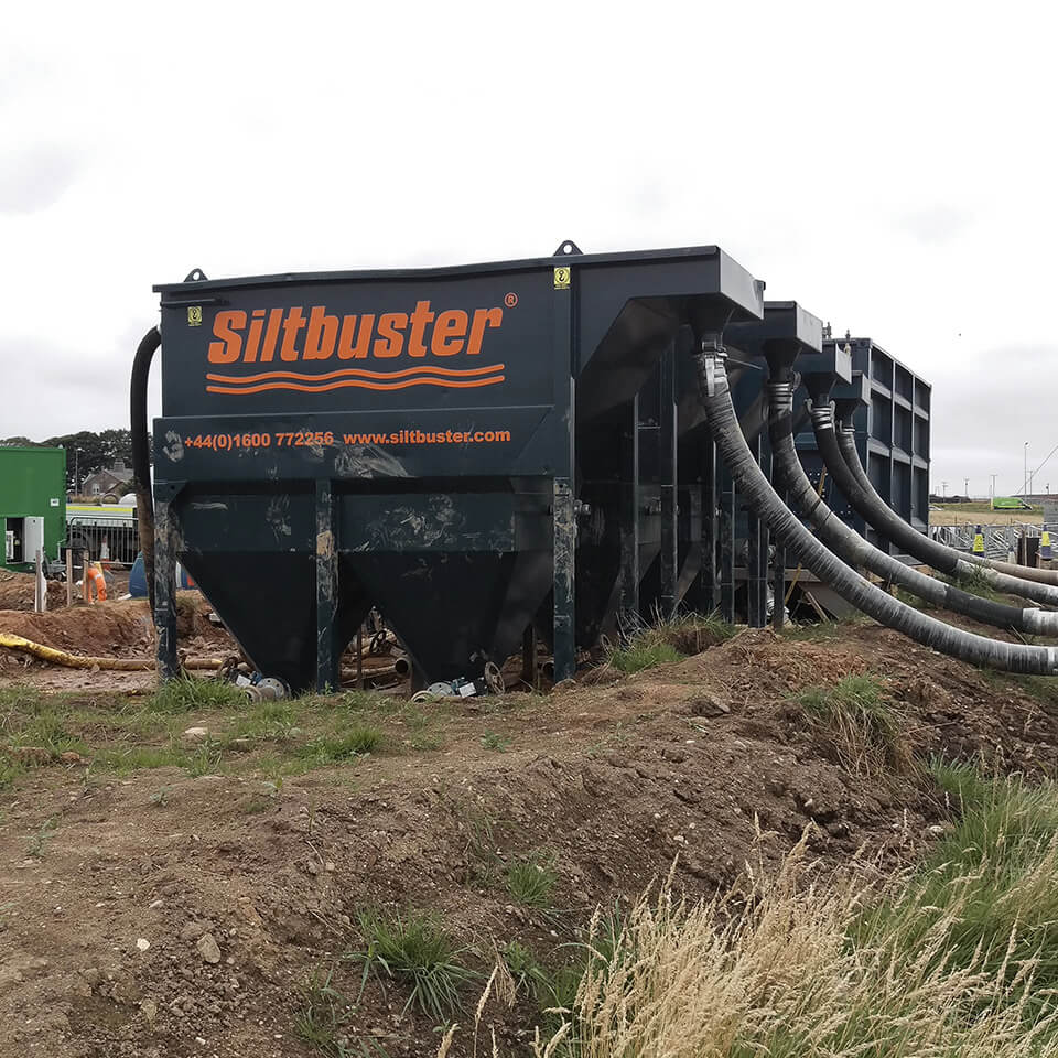
Use of high quality filter drains shown below would benefit treatment of road runoff enormously but these are also not mentioned in design plans. It’s possible that Highways will prefer Vegetative Linear Channels for roadside runoff treatment but these are inferior for the level of volumes of traffic likely. Filter drains are far more effective at treating road runoff for the scale of road traffic likely on the new A23 and M23 feeder road.
Wastewater assessment and risk of impact on the River Mole
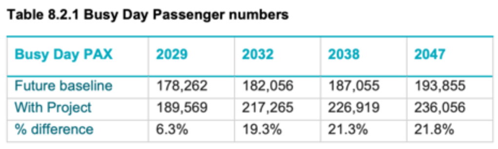
The Project forecasts a 21% increase in daily passenger numbers by 2038. This means passenger numbers will rise to over 200,000 per day by 2030s with attendant increase in waste water flows being conveyed to local sewge works, specifically Horley and Crawley.
Models assume waste water discharges per departing passenger is 8l/h/d (at piers 1l/h/d) for arrivals it is 1.25l/h/d and for workers on site the assumed model discharge is 40l/h/d.
South Terminal waste and wastewater from hotels is conveyed to Horley STW via 6km of trunk sewer system. A gravity network takes waste to (8) airport pumping stations. North Terminal waste is conveyed to Crawley STW in a gravity network with (2?) pumping stations to pump waste across the railway in pipes fixed to bridges.
A total of approximately 16 pumping stations within the airport service waste water conveyance from the airport to sewage treatment works.
While the sewer network is nominally wastewater only, parts of the airport estate discharge storm flows into the sewer network. This means that additional storm water is conveyed to treatment works and may contribute to storm overflows and river pollution downstream. However, the Project’s attenuation and mitigation works are designed to divert storm flows out of wastewater system and reduce pressure on wastewater management and processing.
A study in 2018 showed dry weather sewer capacity is adequate but wet weather capacity stressed the system and caused a risk of sewer flooding in extreme storm events. the study also identified constraints in the network to Horley STWs.
Wastewater modelling is stated as “simplified” as the “network is complex”. The models nevertheless show that the airport wastewater sewer system has the capacity to accommodate increased flows from more passengers and surface water runoff.
In fact, the proposed mitigation works in the project including new pumping stations and new mains will reduce the impact of climate change on the network so that, according to modelling, sewer flood risk will be reduced from existing levels.
The Project seeks betterment in the network within the airport by upgrading pumping stations and constructing a new pumping station to ensure no additional discharge to the Mole.
However, what is not clear is the downstream capacity of sewage treatment works to accommodate the additional wastewater flows from growing passenger numbers.
The capacity of the public sewer network to which the private Gatwick wastewater system discharges and the downstream STW is the responsibility of Thames Water under the terms of its license as the statutory authority. So the sewage treatment works at Horley and Crawley are not the responsibility of Gatwick Airport but clearly the additional flows risk more pollution if treatment works turn out to be unable to cope.
Planning discussions with Thames Water have been ongoing to agree the quantity and distribution of discharges from the airport in the future.
Furthermore, plans suggest that Thames Water, as part of their long-term planning, will undertake an assessment of the impact of wider projected growth in the local area on their sewage treatment works at Horley and Crawley, which would include the impact of the Project. If capacity issues are identified, Thames Water would be responsible for reinforcing their network to support development and they would recoup their costs through infrastructure charges to Gatwick.
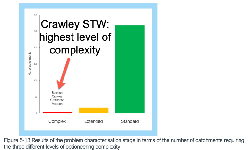
Thames Water are stated as undertaking an assessment of impact of increased passenger numbers on Crawley and Horley STWs but this is not in the public domain yet. It is important to ensure that treatment works are capable of accommodating the additional flows from Gatwick as well as the significant growth in housing and population proposed across the Upper Mole catchment e.g. West of Ifield 10,000 homes.
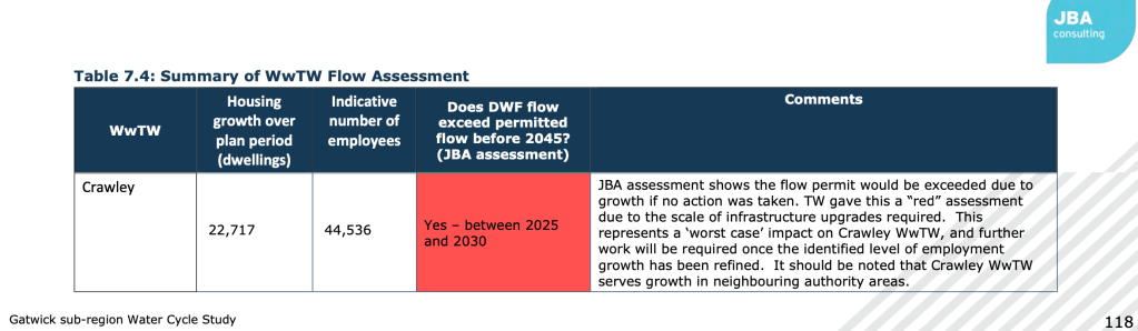
From water cycle assessments conducting for local plans, both Crawley and Horley treatment works are “red flagged” by Thames Water as being challenging to upgrade to meet planned objectives.
In the Thames Wastewater masterplans both treatment works are stated as only being able to accommodate growth by treating waste at unspecified “Technically Achievable Limits”. Horley sewage treatment works already frequently discharges untreated sewage in storm overflows because the storm tanks are full. The use of TAL to accommodate additional wastewater flows from growth at the airport should be questioned to provide more details.
Storm overflows frequently last for many hours after rainfall has ended, sometimes in excess of 24 hours after rainfall has finished. This would suggest Horley is currently not coping with current treatment demands let alone able to achieve spurious “technically achievable limit”.
It is therefore important for Thames Water to provide detailed projections on how it intends to upgrade Horley and Crawley sewage treatment works to achieve its objectives of reducing storm overflows, an insidious existing impact on the health of the River Mole, at the same time as meeting increased demand of growth and the challenge presented by climate change.
Airport Water Supply
The airport is currently supplied with water via a 300mm main which provides for fire hydrants supply too. It is my understanding that Gatwick is supplied entirely by Bough Beech Reservoir from the River Eden catchment. Consumption is forecast to increase to 749 megalitres per year by 2028 and 946 megalitres by 2038 (assuming no water efficiencies are made). Of note here is that the Bough Beech Reservoir abstracts water from the River Eden. Such surface abstraction is vulnerable to the impact of climate change, for example due to prolonged droughts and heat waves when reservoir levels can fall quickly.
In the ‘Gatwick Sub-region’ Water Cycle Study (2020), SESW stated that there was sufficient capacity to meet projected demand. SESW not stated that their sources would not be able to meet the additional demands of the Project.
It is important to note here that, as part of the Decade of Change policy, Gatwick is trying to address airport water consumption. It is aiming to significantly reduce the consumption of potable water by 2030. This policy is independent of the Northern Runway plans and will hopefully proceed at pace regardless of whether the runway goes ahead or not.
8. Water:
Reduce the airport’s potable water consumption by 50% on a per passenger basis by 2030 compared to 2019, continue to improve the quality of water leaving the airport and work with partners to promote local water stewardship.
Gatwick Decade of Change Policy to 20230
Nevertheless, more clarity on the sustainability of water supply is needed because the assessment does not appear to cover the wider regional deficiencies and looming deficits in water supply outlined unequivocally in WRSE management plans which, not least, highlights the risk of relying on surface water abstraction from vulnerable rivers such as the Eden. The statement suggests that SESW will undertake an impact assessment of the Project on their water network to identify necessary upgrades as a result of projected increases in water demand. “A response from SESW is awaited”: this assessment is required as the SE region is facing serious water deficits in the near future exacerbated by growth and climate change.
Construction period risks
There are serious risks to the water environment during construction. For example:
- Vegetation and soil stripping for excavation works could allow runoff to convey harmful substances liberated from disturbance into water courses.
- Sediment load from construct sites and roads could increase if runoff is not treated.
- Runoff from construction areas can entrain toxic pollutants which risk entering the river.
- Alterations in pH and turbidity.
- Accidental spillage fuels oils lubricants from construction sites, traffic spills and road runoff.
- Temporary storage of “inert spoil” on the Pentagon Field east of airfield could reduce flood plain storage and increase sedimentation and polluted runoff entering water courses.
More detail on how construction codes and practices will reduce these risks to the river is needed.
Summary points and questions
Overall, the Northern Runway Project has schemes that could improve on existing flood risk mitigation and water quality management. Several schemes seek to improve the local river environment and access to it. Examples of welcome improvements include the Museum Field FCA, the Gatwick Stream de-culverting section, the new arrangements for de-icer processing, improvements to the runway culvert and the flood plain downstream.
However, a number of questions can be asked of elements of the plans so that the river is able to not just survive the Project but has the opportunity to thrive and reach “Good” ecological status in the future. Key points to raise are as follows:
Flood Risk Summary Points:
- Are the published climate change allowances and adaptations sufficient to build resilience and provide safety for users and residents into the future?
The Flood Risk Assessment recognises that the main source of future fluvial flood risk and surface water flood risk at the airport is from CLIMATE CHANGE. However, while 40% climate change allowance has been provided for surface water flooding, only a 16% allowance has been added to peak river flows. Is the fluvial 1% AEP level and climate change allowance of 16% sufficiently resilient? Clarification is needed to confirm if 16% climate change allowance was used to model future change in fluvial peak flows. If so, it seems too low for national infrastructure of this scale. An allowance for the 2050’s upper end 26% or Upper 40% arguably should be used. Furthermore, the use of 40 years as a lifespan to account for climate change uplift seems too short for a nationally important infrastructure. Both these points need justification and supporting evidence.
Modelling flood mitigation on 100 year events seems insufficient. The extreme events observed recently suggests relying on 1% AEP or 100 year return period as the baseline extreme could turn out to be woefully inadequate to protect such important national infrastructure. As warming continues the extreme “tail” of storm risk, whilst low probability, threatens to deliver rainfall intensity and flood peaks that are far outside historic observations and may “bust through” 100 year return periods into 1000’s of years. Whether modelling flood mitigation for the 100 year level storm delivers a climate-resilient airport through the next century and for the lifespan of the airport, set at just 40 years, is uncertain. On the other hand, the airport is already in situ and there is no choice to move it so perhaps this level of risk is acceptable.
- Are contingency plans and warning times for extreme events sufficiently robust?
Contingency plans for exceedance events also need some elaboration. According to modelling, due to the relatively flat topography at the airport, flood water would be expected to rise only gradually and would not flow at significant velocities. The official assessment concludes that there is “little to no risk of fatality as a result of fluvial flooding at the airport.”
Furthermore, the FRA in the Environmental Statement states that..
Hydraulic modelling shows there will be safe routes of exit from the terminals onto the A23 and M23 in all conceivable flood scenarios. The railway line is also expected to be available but experience shows may be susceptible to flooding and be withdrawn from service.
5.3 Environmental Statement – Appendix 11.9.6 Flood Risk Assessment – Annexes 3-6 5.3.1
Contingency plans predict that in flooding up to the 1% AEP event (1 in 100 years) the airport will be able to remain open and to manage the situation, if necessary by evacuating persons to safe and dry areas. Progressive withdrawal of facilities from service will occur, and evacuation of areas likely to be affected by flooding. It is expected that extreme flooding could take 24 hours to recede after which the airport will be able to resume operations. The FRA points out that in such extreme events the impacts are likely to extend well beyond the airport.
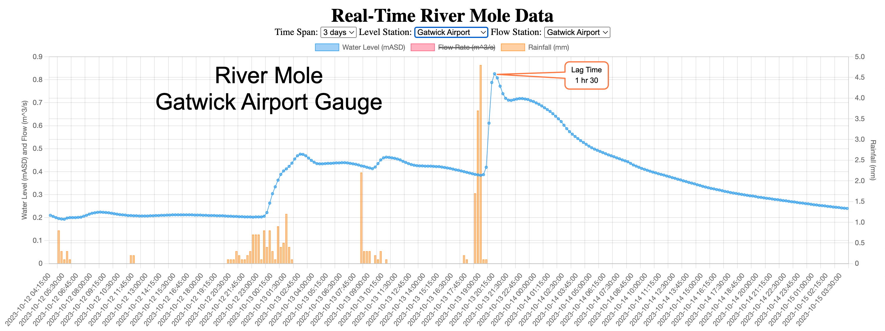
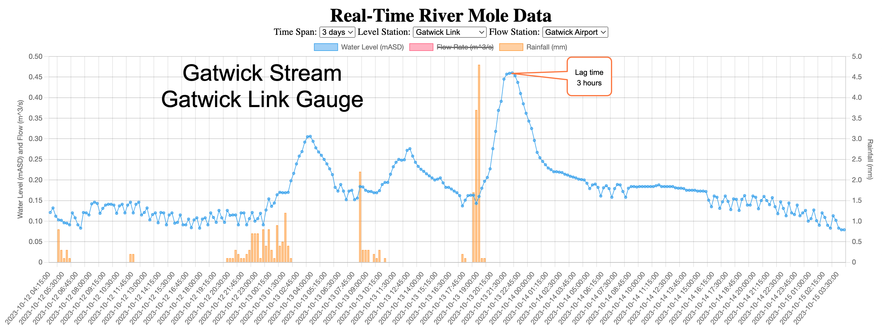
However, regarding warning time, attention should be drawn to the very short lag times characterised by the rivers running through Gatwick. Typically, the time between peak rainfall and peak discharge for the River Mole at the Gatwick gauging station has a range from 1-5 hours depending on the season and antecedent conditions. The time between peak rainfall and peak discharge for the Gatwick Stream at the Gatwick Link gauging station is similar but usually lags by 1.5 to 2 hours after the River Mole has peaked. This means that the time between exceptional rainfall and rising flood waters at the airport might be in the order of a few hours. Reference to this short warning time is not explicit in the planning documentation but ought to be.
- More clarity and modelling is needed on the risks of local impacts from plans to attenuate and wiggle the river: 1)Impact of gradient on discharge 2)risk of flood peak synchronisation due to upstream attenuation; 3) flooding into original Withey Brook catchment from exceedance event in realigned Mole corridor 4)Footpath access
1)The increase in length of realigned channel re-wiggling downstream of culvert will reduce gradient from already shallow 1:1250 to 1:1890 this could slow flow, reduce velocity causing deposition at location and possible increase erosion downstream. How will this be monitored and mitigated and by which agency?
2)Provide evidence for desynchronising flood peaks from attenuation schemes, particularly to avoid synchronising with Gatwick Stream flood peaks. Model flood peaks to confirm no unintended synchronisation of flood peaks due to attenuation in new FCA and flood storage areas e.g. Museum Field
3)Provide modelling evidence of the risk of flood peaks overspilling from the realigned Mole Corridor into the Withey Brook catchment with risks to Hookwood and new developments and the A217 as well as Tesco supermarket.
4)A call for better integration of the public access arrangements to connect more safely to public footpath networks e.g. Horley Road crossing
Water Quality Mitigation Measures
- Road runoff is a toxic threat to water courses. Robust mitigation and treatment is uncertain and not clear in plans. Have tests on the quality of road runoff been provided for accurate modelling?
Road runoff treatment and drainage arrangements are unclear with no mention of poly-aromatic hydrocarbons (PAH) treatment or evidence of sampling of existing road runoff to include Priority Substances. Samples of road runoff from the M23 spur and A23 into existing drains are needed to provide clear evidence of the quality of road runoff and feedback into models for an accurate assessment of the impact of proposed road widening plans.
- Can more detail be provided on the plans for car park upgrades and how these will address “insufficiencies” and mitigate firewater risks?
Clear plans are needed to improve water quality of runoff car parks which have been assessed as insufficient in the application.
Contingency plans to mitigate the risk of firewater used to extinguish fires in car parks and elsewhere from entering water courses needs to be provided.
Airport Wastewater assessment and water supply
The SESW water supply assessment and impact of increased foul and surface water flows on wastewater management by Thames Water are both required to enable the impact and increased demands of the application on water supply and local wastewater treatment to be assessed.
The impact of additional water abstraction from the Eden catchment and its impact on water neutrality must be provided and assessed.
The impact of increased wastewater flows to Horley and Crawley sewage treatment works, both red flagged as challenging to upgrade, must be fully assessed, and mitigation required to reduce storm overflows or other pollution incidents set out clearly.
Construction Period Risks
More detail is needed on how construction codes and practices will reduce risks to water courses.
Plans for new water quality treatment “airside” appear to provide significant improvements with new treatment processing for de-icer, improvements to car park treatment and river channel restoration. However, more detail is needed on each of these schemes and if they are sufficient to enable future improvement in water quality to achieve WFD “Good” status in the future.
An opportunity for further developing community engagement
The Project provides an opportunity to put forward a better deal for local residents by upgrading planned improvements to the river environment. Providing residents with improved access to river environments surrounding the airport is vital to provide resilient improvements to river quality, habitat and at the same time provide recreational environments enhancing the health and wellbeing of local people. Furthermore, improvements to the dire state of active travel access from Longbridge to Gatwick and public footpath networks beyond, must be addressed an area to urgently improve.
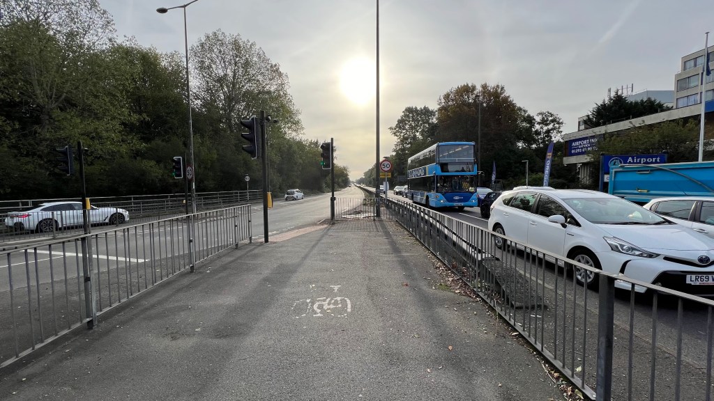
For example, a foot / cycle bridge across the A23 linking Riverside with the Mole corridor would serve local people better than continuing to force pedestrians and cyclists across a larger and busier Longbridge roundabout.
Further engagement is welcomed with charities such as River Mole River Watch to further evolve local ownership and understanding and responsibility for river environments surrounding the airport.
Thank you for reading my post on how the Northern Runway Project at Gatwick impacts the water environment in the River Mole catchment. Do leave comments below and, if you have found it useful, please make a donation to help keep my work on this going by using the “Buy Me a Coffee” button. Thank you!
References
My sincere thanks to Jo Bradley of Storm Water Shepherds for her expert input and assessment of road runoff issues. I am enormously grateful for your advice and expertise. https://www.stormwatershepherds.org.uk/

Leave a comment