River level Gatwick https://www.gaugemap.co.uk/#!Detail/1232
River Levels Horley: https://www.gaugemap.co.uk/#/!Detail/1236
River level Kinnersley Manor (Reigate) https://www.gaugemap.co.uk/#!Detail/1232
National river flow archive: UK river gauging stations nationwide https://nrfa.ceh.ac.uk/data/search
Government webpage on river levels, flood warnings, ground water levels and rainfall: https://check-for-flooding.service.gov.uk/rainfall-station/284703TP?v=map&lyr=mv,rf&fid=rainfall_stations.284703TP.Thames&ext=-0.363661,51.060683,0.048584,51.278505
DEFRA Gov website on river discharge (m3/s) over longer periods https://environment.data.gov.uk/hydrology/station/ad19b458-9e76-4c18-8ebc-d2a959156f82
DEFRA Mole catchment data explorer: pollution status https://environment.data.gov.uk/catchment-planning/ManagementCatchment/3058
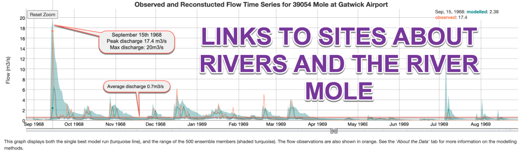
UKCEH website: UK reconstructed flow data explorer https://shiny-apps.ceh.ac.uk/reconstruction_explorer/
UK River Basin management plans (ARCGIS map) includes pollution status https://experience.arcgis.com/experience/73ed24b6d30441648f24f043e75ebed2/page/Classification/
River Mole catchment portal ARCGIS map : https://southeastrivers.maps.arcgis.com/apps/MapSeries/index.html?appid=525a1f141084458aa40ec65ec3f9ac7e
River Mole catchment partnership https://environment.data.gov.uk/catchment-planning/v/c3-plan/CatchmentPartnership/WEIF4401
RIVERS TRUST storm overflows map data 2021 https://data.catchmentbasedapproach.org/datasets/theriverstrust::event-duration-monitoring-storm-overflows-2021-england-and-wales/about
Rivers Trust alternative map: how healthy are our rivers? https://theriverstrust.maps.arcgis.com/apps/MapJournal/index.html?appid=1798f2be345a43b7b131f1f2b526c71d
UKCEH water resources portal including current raw data (Standardised Streamflow Index) on historic river regimes for gauging stations and comparison years with historic droughts https://eip.ceh.ac.uk/hydrology/water-resources/
River Search map 2016 https://www.google.com/maps/d/viewer?mid=1pEqyZrJb_omjoDUUda5n2_wgfdU&ll=51.23736972367193%2C-0.2763962500000017&z=12
Gov.uk flood risk map https://check-long-term-flood-risk.service.gov.uk/map
Charlwood weather station averages https://www.metoffice.gov.uk/research/climate/maps-and-data/uk-climate-averages/gcpffxw47
Lower Mole flood alleviation scheme https://consult.environment-agency.gov.uk/ksles/lower-mole-flood-alleviation-scheme/
Environment Agency Lower Mole Flood Alleviation Scheme https://www.lowermolefloodalleviationscheme.co.uk/
